|
|
|||||||||||||||||
| Point ID: 8874 | Downloads | Plots | Site Data | Code: 70460 |
|
|
|||||||||||||||||
| Download | |
|---|---|
| Site Descriptor Information | Site Time Series Data |
| Link to all available data | |
| View: | Time Series | All |
| Units: | mm |
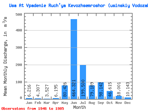
| Statistic | Jan | Feb | Mar | Apr | May | Jun | Jul | Aug | Sep | Oct | Nov | Dec | Annual |
|---|---|---|---|---|---|---|---|---|---|---|---|---|---|
| Mean | 6.22 | 4.31 | 3.53 | 6.20 | 80.43 | 464.32 | 199.50 | 79.19 | 98.14 | 46.62 | 18.00 | 10.14 | 84.99 |
| Standard Deviation | 2.12 | 1.75 | 1.54 | 6.84 | 101.75 | 129.34 | 106.22 | 37.11 | 45.08 | 26.93 | 7.93 | 3.71 | 12.77 |
| Min | 2.29 | 1.13 | 0.84 | 1.22 | 3.75 | 217.00 | 85.40 | 32.50 | 34.30 | 8.91 | 6.14 | 2.07 | 58.48 |
| Max | 10.70 | 9.14 | 6.52 | 36.80 | 406.00 | 722.00 | 468.00 | 168.00 | 209.00 | 105.00 | 34.40 | 19.70 | 112.67 |
| Coefficient of Variation | 0.34 | 0.41 | 0.44 | 1.10 | 1.27 | 0.28 | 0.53 | 0.47 | 0.46 | 0.58 | 0.44 | 0.37 | 0.15 |
 Return to R-Arctic Net Home Page