|
|
|||||||||||||||||
| Point ID: 8874 | Downloads | Plots | Site Data | Code: 70460 |
|
|
|||||||||||||||||
| Download | |
|---|---|
| Site Descriptor Information | Site Time Series Data |
| Link to all available data | |
|
|
| View: | Statistics | Time Series |
| Units: | m3/s |
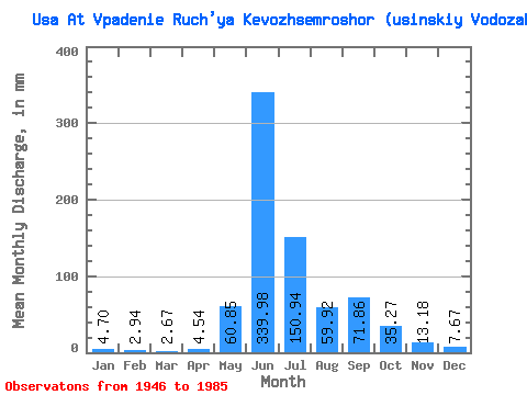
| Statistic | Jan | Feb | Mar | Apr | May | Jun | Jul | Aug | Sep | Oct | Nov | Dec | Annual |
|---|---|---|---|---|---|---|---|---|---|---|---|---|---|
| Mean | 4.70 | 2.97 | 2.67 | 4.54 | 60.84 | 339.98 | 150.92 | 59.91 | 71.86 | 35.26 | 13.18 | 7.67 | 757.68 |
| Standard Deviation | 1.61 | 1.21 | 1.16 | 5.01 | 76.97 | 94.70 | 80.35 | 28.08 | 33.01 | 20.37 | 5.81 | 2.81 | 113.82 |
| Min | 1.73 | 0.78 | 0.64 | 0.89 | 2.84 | 158.89 | 64.61 | 24.59 | 25.11 | 6.74 | 4.50 | 1.57 | 521.39 |
| Max | 8.10 | 6.30 | 4.93 | 26.95 | 307.14 | 528.65 | 354.04 | 127.09 | 153.03 | 79.43 | 25.19 | 14.90 | 1004.45 |
| Coefficient of Variation | 0.34 | 0.41 | 0.44 | 1.10 | 1.27 | 0.28 | 0.53 | 0.47 | 0.46 | 0.58 | 0.44 | 0.37 | 0.15 |
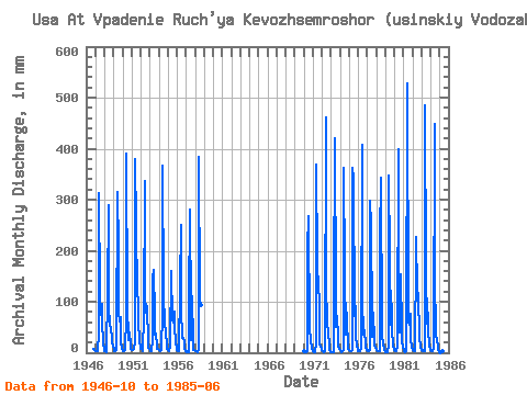
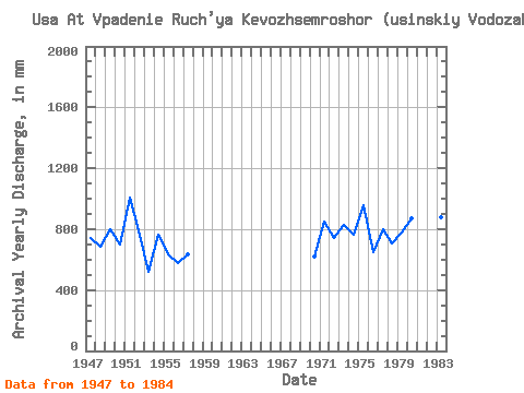
| Year | Jan | Feb | Mar | Apr | May | Jun | Jul | Aug | Sep | Oct | Nov | Dec | Annual | 1946 | 6.74 | 7.12 | 5.75 | 1947 | 4.39 | 2.81 | 2.47 | 4.23 | 38.05 | 311.92 | 119.53 | 76.41 | 95.19 | 60.97 | 19.70 | 5.30 | 741.99 | 1948 | 3.57 | 2.76 | 1.47 | 3.16 | 120.28 | 289.95 | 90.78 | 59.46 | 46.35 | 32.68 | 21.45 | 11.42 | 683.12 | 1949 | 7.47 | 3.95 | 2.86 | 5.06 | 15.73 | 314.12 | 210.31 | 80.19 | 62.09 | 73.23 | 18.60 | 9.76 | 802.37 | 1950 | 3.77 | 3.43 | 4.83 | 4.85 | 74.14 | 390.26 | 96.83 | 27.08 | 25.11 | 41.91 | 14.79 | 8.70 | 697.75 | 1951 | 6.60 | 4.47 | 4.90 | 8.13 | 20.80 | 378.55 | 258.72 | 117.26 | 106.90 | 64.68 | 22.99 | 11.20 | 1004.45 | 1952 | 8.10 | 6.30 | 4.93 | 3.70 | 73.53 | 337.55 | 119.53 | 80.94 | 91.53 | 19.14 | 9.08 | 7.35 | 763.01 | 1953 | 3.24 | 2.55 | 2.27 | 26.95 | 151.30 | 162.55 | 75.12 | 36.24 | 37.20 | 11.73 | 6.80 | 6.97 | 521.39 | 1954 | 5.13 | 3.73 | 3.80 | 5.39 | 81.70 | 366.83 | 122.55 | 52.58 | 59.16 | 37.90 | 16.48 | 8.62 | 765.13 | 1955 | 6.03 | 3.61 | 2.38 | 13.18 | 166.43 | 158.89 | 64.61 | 61.43 | 81.28 | 49.10 | 22.48 | 7.07 | 634.39 | 1956 | 5.14 | 2.96 | 3.43 | 4.03 | 135.41 | 249.68 | 89.27 | 29.81 | 28.63 | 20.12 | 8.27 | 3.86 | 579.96 | 1957 | 2.79 | 1.98 | 1.52 | 1.00 | 98.34 | 281.17 | 82.46 | 24.59 | 110.56 | 21.26 | 5.27 | 5.21 | 637.90 | 1958 | 3.69 | 2.26 | 2.32 | 1.35 | 8.62 | 383.68 | 106.67 | 96.08 | 1970 | 2.34 | 0.78 | 1.23 | 1.68 | 3.65 | 205.02 | 276.88 | 42.21 | 50.23 | 21.48 | 11.64 | 6.91 | 621.70 | 1971 | 4.01 | 2.63 | 2.06 | 2.09 | 17.78 | 369.03 | 181.56 | 127.09 | 105.44 | 19.29 | 11.28 | 7.94 | 851.11 | 1972 | 5.28 | 2.38 | 2.19 | 3.51 | 3.97 | 462.02 | 133.90 | 66.65 | 35.51 | 18.84 | 4.50 | 1.57 | 743.74 | 1973 | 2.16 | 0.91 | 1.21 | 1.74 | 113.47 | 420.29 | 113.47 | 51.22 | 72.34 | 32.08 | 12.89 | 6.92 | 830.46 | 1974 | 5.74 | 2.90 | 2.10 | 3.21 | 5.24 | 363.17 | 165.67 | 37.37 | 90.06 | 70.35 | 10.62 | 8.17 | 766.38 | 1975 | 5.51 | 3.49 | 3.69 | 3.92 | 4.87 | 363.17 | 354.04 | 74.29 | 91.53 | 33.81 | 12.30 | 7.72 | 956.84 | 1976 | 4.43 | 2.10 | 2.29 | 3.90 | 7.21 | 407.11 | 107.42 | 36.84 | 43.05 | 16.95 | 10.18 | 6.67 | 651.85 | 1977 | 4.75 | 3.48 | 3.01 | 4.86 | 307.14 | 249.68 | 68.84 | 32.38 | 77.61 | 25.87 | 13.03 | 9.38 | 797.28 | 1978 | 6.36 | 3.71 | 3.33 | 2.97 | 3.36 | 224.05 | 353.28 | 44.48 | 34.85 | 16.04 | 8.86 | 6.49 | 704.28 | 1979 | 1.73 | 0.89 | 0.79 | 0.89 | 14.37 | 346.33 | 195.93 | 55.75 | 95.19 | 46.98 | 11.28 | 7.72 | 778.78 | 1980 | 5.15 | 3.21 | 3.20 | 3.13 | 11.57 | 398.32 | 174.75 | 40.02 | 153.03 | 43.35 | 18.16 | 14.90 | 872.19 | 1981 | 4.39 | 3.06 | 1.94 | 2.48 | 4.96 | 528.65 | 69.45 | 60.22 | 54.40 | 79.43 | 25.19 | 12.10 | 851.28 | 1982 | 5.35 | 3.60 | 3.53 | 3.90 | 206.52 | 226.25 | 122.55 | 111.96 | 116.42 | 30.64 | 13.25 | 9.08 | 849.84 | 1983 | 6.28 | 4.56 | 3.44 | 2.96 | 3.96 | 485.45 | 161.13 | 59.76 | 77.61 | 44.71 | 14.72 | 7.56 | 875.88 | 1984 | 5.82 | 3.43 | 2.87 | 3.11 | 8.32 | 447.38 | 159.62 | 35.18 | 27.09 | 12.86 | 4.95 | 2.83 | 716.71 | 1985 | 2.44 | 1.19 | 0.64 | 1.66 | 2.84 | 398.32 |
|---|
 Return to R-Arctic Net Home Page