|
|
|||||||||||||||||
| Point ID: 8874 | Downloads | Plots | Site Data | Code: 70460 |
|
|
|||||||||||||||||
| Download | |
|---|---|
| Site Descriptor Information | Site Time Series Data |
| Link to all available data | |
|
|
| View: | Statistics | Time Series |
| Units: | mm |
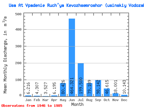
| Statistic | Jan | Feb | Mar | Apr | May | Jun | Jul | Aug | Sep | Oct | Nov | Dec | Annual |
|---|---|---|---|---|---|---|---|---|---|---|---|---|---|
| Mean | 6.22 | 4.31 | 3.53 | 6.20 | 80.43 | 464.32 | 199.50 | 79.19 | 98.14 | 46.62 | 18.00 | 10.14 | 84.99 |
| Standard Deviation | 2.12 | 1.75 | 1.54 | 6.84 | 101.75 | 129.34 | 106.22 | 37.11 | 45.08 | 26.93 | 7.93 | 3.71 | 12.77 |
| Min | 2.29 | 1.13 | 0.84 | 1.22 | 3.75 | 217.00 | 85.40 | 32.50 | 34.30 | 8.91 | 6.14 | 2.07 | 58.48 |
| Max | 10.70 | 9.14 | 6.52 | 36.80 | 406.00 | 722.00 | 468.00 | 168.00 | 209.00 | 105.00 | 34.40 | 19.70 | 112.67 |
| Coefficient of Variation | 0.34 | 0.41 | 0.44 | 1.10 | 1.27 | 0.28 | 0.53 | 0.47 | 0.46 | 0.58 | 0.44 | 0.37 | 0.15 |
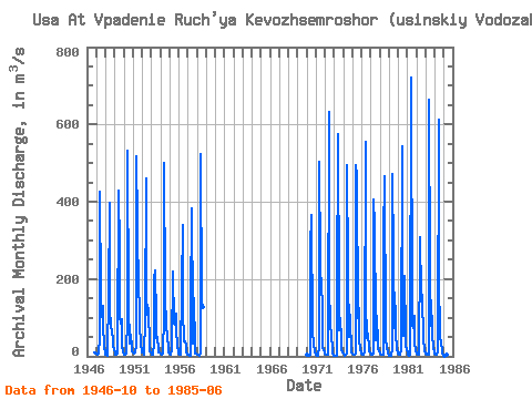
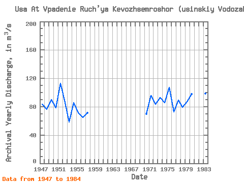
| Year | Jan | Feb | Mar | Apr | May | Jun | Jul | Aug | Sep | Oct | Nov | Dec | Annual | 1946 | 8.91 | 9.73 | 7.60 | 1947 | 5.81 | 4.07 | 3.26 | 5.78 | 50.30 | 426.00 | 158.00 | 101.00 | 130.00 | 80.60 | 26.90 | 7.01 | 83.23 | 1948 | 4.72 | 4.01 | 1.94 | 4.31 | 159.00 | 396.00 | 120.00 | 78.60 | 63.30 | 43.20 | 29.30 | 15.10 | 76.62 | 1949 | 9.88 | 5.73 | 3.78 | 6.91 | 20.80 | 429.00 | 278.00 | 106.00 | 84.80 | 96.80 | 25.40 | 12.90 | 90.00 | 1950 | 4.99 | 4.97 | 6.39 | 6.62 | 98.00 | 533.00 | 128.00 | 35.80 | 34.30 | 55.40 | 20.20 | 11.50 | 78.26 | 1951 | 8.73 | 6.49 | 6.48 | 11.10 | 27.50 | 517.00 | 342.00 | 155.00 | 146.00 | 85.50 | 31.40 | 14.80 | 112.67 | 1952 | 10.70 | 9.14 | 6.52 | 5.05 | 97.20 | 461.00 | 158.00 | 107.00 | 125.00 | 25.30 | 12.40 | 9.71 | 85.58 | 1953 | 4.28 | 3.70 | 3.00 | 36.80 | 200.00 | 222.00 | 99.30 | 47.90 | 50.80 | 15.50 | 9.29 | 9.22 | 58.48 | 1954 | 6.78 | 5.41 | 5.02 | 7.36 | 108.00 | 501.00 | 162.00 | 69.50 | 80.80 | 50.10 | 22.50 | 11.40 | 85.82 | 1955 | 7.97 | 5.24 | 3.15 | 18.00 | 220.00 | 217.00 | 85.40 | 81.20 | 111.00 | 64.90 | 30.70 | 9.34 | 71.16 | 1956 | 6.80 | 4.29 | 4.54 | 5.50 | 179.00 | 341.00 | 118.00 | 39.40 | 39.10 | 26.60 | 11.30 | 5.10 | 65.05 | 1957 | 3.69 | 2.87 | 2.01 | 1.36 | 130.00 | 384.00 | 109.00 | 32.50 | 151.00 | 28.10 | 7.20 | 6.89 | 71.55 | 1958 | 4.88 | 3.28 | 3.07 | 1.85 | 11.40 | 524.00 | 141.00 | 127.00 | 1970 | 3.10 | 1.13 | 1.63 | 2.30 | 4.82 | 280.00 | 366.00 | 55.80 | 68.60 | 28.40 | 15.90 | 9.13 | 69.73 | 1971 | 5.30 | 3.81 | 2.73 | 2.86 | 23.50 | 504.00 | 240.00 | 168.00 | 144.00 | 25.50 | 15.40 | 10.50 | 95.47 | 1972 | 6.98 | 3.46 | 2.89 | 4.79 | 5.25 | 631.00 | 177.00 | 88.10 | 48.50 | 24.90 | 6.14 | 2.07 | 83.42 | 1973 | 2.85 | 1.32 | 1.60 | 2.38 | 150.00 | 574.00 | 150.00 | 67.70 | 98.80 | 42.40 | 17.60 | 9.15 | 93.15 | 1974 | 7.58 | 4.20 | 2.77 | 4.38 | 6.92 | 496.00 | 219.00 | 49.40 | 123.00 | 93.00 | 14.50 | 10.80 | 85.96 | 1975 | 7.29 | 5.06 | 4.88 | 5.35 | 6.44 | 496.00 | 468.00 | 98.20 | 125.00 | 44.70 | 16.80 | 10.20 | 107.33 | 1976 | 5.86 | 3.05 | 3.03 | 5.32 | 9.53 | 556.00 | 142.00 | 48.70 | 58.80 | 22.40 | 13.90 | 8.81 | 73.12 | 1977 | 6.28 | 5.05 | 3.98 | 6.63 | 406.00 | 341.00 | 91.00 | 42.80 | 106.00 | 34.20 | 17.80 | 12.40 | 89.43 | 1978 | 8.40 | 5.39 | 4.40 | 4.06 | 4.44 | 306.00 | 467.00 | 58.80 | 47.60 | 21.20 | 12.10 | 8.58 | 79.00 | 1979 | 2.29 | 1.29 | 1.05 | 1.22 | 19.00 | 473.00 | 259.00 | 73.70 | 130.00 | 62.10 | 15.40 | 10.20 | 87.35 | 1980 | 6.81 | 4.66 | 4.23 | 4.28 | 15.30 | 544.00 | 231.00 | 52.90 | 209.00 | 57.30 | 24.80 | 19.70 | 97.83 | 1981 | 5.80 | 4.44 | 2.56 | 3.38 | 6.55 | 722.00 | 91.80 | 79.60 | 74.30 | 105.00 | 34.40 | 16.00 | 95.49 | 1982 | 7.07 | 5.23 | 4.67 | 5.32 | 273.00 | 309.00 | 162.00 | 148.00 | 159.00 | 40.50 | 18.10 | 12.00 | 95.32 | 1983 | 8.30 | 6.61 | 4.55 | 4.04 | 5.24 | 663.00 | 213.00 | 79.00 | 106.00 | 59.10 | 20.10 | 10.00 | 98.25 | 1984 | 7.69 | 4.97 | 3.79 | 4.25 | 11.00 | 611.00 | 211.00 | 46.50 | 37.00 | 17.00 | 6.76 | 3.74 | 80.39 | 1985 | 3.23 | 1.72 | 0.84 | 2.27 | 3.75 | 544.00 |
|---|
 Return to R-Arctic Net Home Page