|
|
|||||||||||||||||
| Point ID: 8652 | Downloads | Plots | Site Data | Code: 11444 |
|
|
|||||||||||||||||
| Download | |
|---|---|
| Site Descriptor Information | Site Time Series Data |
| Link to all available data | |
|
|
| View: | Statistics | Time Series |
| Units: | mm |
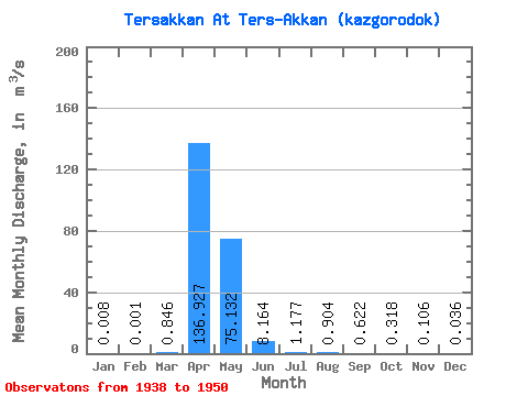
| Statistic | Jan | Feb | Mar | Apr | May | Jun | Jul | Aug | Sep | Oct | Nov | Dec | Annual |
|---|---|---|---|---|---|---|---|---|---|---|---|---|---|
| Mean | 0.01 | 0.00 | 0.85 | 136.93 | 75.13 | 8.16 | 1.18 | 0.90 | 0.62 | 0.32 | 0.11 | 0.04 | 18.69 |
| Standard Deviation | 0.02 | 0.00 | 2.53 | 107.23 | 90.49 | 8.66 | 0.81 | 0.69 | 0.50 | 0.34 | 0.23 | 0.11 | 15.73 |
| Min | 0.00 | 0.00 | 0.00 | 0.27 | 0.66 | 0.06 | 0.00 | 0.00 | 0.00 | 0.00 | 0.00 | 0.00 | 0.13 |
| Max | 0.08 | 0.00 | 8.43 | 282.00 | 309.00 | 26.20 | 2.17 | 1.84 | 1.39 | 1.10 | 0.77 | 0.36 | 46.66 |
| Coefficient of Variation | 3.11 | 1.45 | 2.99 | 0.78 | 1.20 | 1.06 | 0.68 | 0.77 | 0.80 | 1.08 | 2.22 | 3.03 | 0.84 |
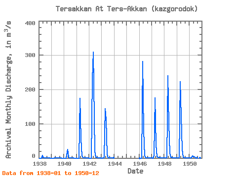
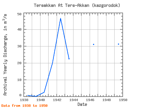
| Year | Jan | Feb | Mar | Apr | May | Jun | Jul | Aug | Sep | Oct | Nov | Dec | Annual | 1938 | 0.00 | 0.00 | 0.00 | 7.37 | 0.66 | 0.06 | 0.01 | 0.01 | 0.00 | 0.01 | 0.01 | 0.00 | 0.68 | 1939 | 0.00 | 0.00 | 0.00 | 0.27 | 1.16 | 0.15 | 0.01 | 0.00 | 0.00 | 0.00 | 0.00 | 0.00 | 0.13 | 1940 | 0.00 | 0.00 | 0.00 | 25.60 | 2.58 | 0.09 | 0.00 | 0.00 | 0.02 | 0.01 | 0.00 | 0.00 | 2.36 | 1941 | 0.00 | 0.00 | 0.00 | 174.00 | 56.00 | 5.82 | 1.48 | 0.90 | 0.52 | 0.20 | 0.02 | 0.00 | 19.91 | 1942 | 0.00 | 0.00 | 0.00 | 228.00 | 309.00 | 18.70 | 1.65 | 1.51 | 0.80 | 0.20 | 0.01 | 0.00 | 46.66 | 1943 | 0.00 | 0.00 | 0.00 | 144.00 | 112.00 | 10.70 | 1.22 | 1.29 | 0.94 | 0.40 | 0.00 | 0.00 | 22.55 | 1946 | 0.00 | 0.00 | 0.00 | 282.00 | 79.10 | 6.57 | 1.40 | 1.11 | 1.17 | 1.10 | 0.77 | 0.36 | 31.13 | 1947 | 0.08 | 0.00 | 8.43 | 175.00 | 37.30 | 3.49 | 1.94 | 1.84 | 1.39 | 0.75 | 0.05 | 0.00 | 19.19 | 1948 | 0.00 | 0.00 | 0.85 | 240.00 | 100.00 | 15.40 | 2.17 | 1.82 | 1.11 | 0.29 | 0.01 | 0.00 | 30.14 | 1949 | 0.00 | 0.00 | 0.02 | 223.00 | 123.00 | 26.20 | 1.85 | 0.54 | 0.43 | 0.41 | 0.28 | 0.02 | 31.31 | 1950 | 0.00 | 0.00 | 0.01 | 6.96 | 5.65 | 2.62 | 1.21 | 0.91 | 0.46 | 0.12 | 0.00 | 0.00 | 1.50 |
|---|
 Return to R-Arctic Net Home Page