|
|
|||||||||||||||||
| Point ID: 8378 | Downloads | Plots | Site Data | Code: 9459 |
|
|
|||||||||||||||||
| Download | |
|---|---|
| Site Descriptor Information | Site Time Series Data |
| Link to all available data | |
|
|
| View: | Statistics | Time Series |
| Units: | mm |
| Statistic | Jan | Feb | Mar | Apr | May | Jun | Jul | Aug | Sep | Oct | Nov | Dec | Annual |
|---|---|---|---|---|---|---|---|---|---|---|---|---|---|
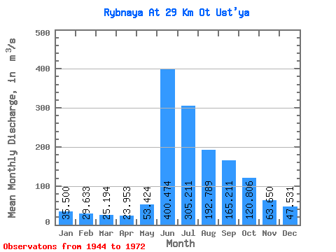
| Mean | 35.50 | 29.63 | 25.19 | 23.95 | 53.42 | 400.47 | 305.21 | 192.79 | 165.21 | 120.81 | 63.65 | 47.53 | 121.39 |
| Standard Deviation | 7.59 | 6.49 | 5.61 | 5.80 | 32.39 | 93.00 | 63.98 | 51.70 | 41.25 | 34.02 | 15.66 | 10.63 | 16.88 |
| Min | 22.10 | 21.20 | 17.30 | 16.60 | 17.30 | 157.00 | 182.00 | 115.00 | 120.00 | 75.30 | 37.00 | 30.00 | 88.87 |
| Max | 49.20 | 42.80 | 37.10 | 36.80 | 134.00 | 538.00 | 407.00 | 323.00 | 277.00 | 199.00 | 92.20 | 68.80 | 153.60 |
| Coefficient of Variation | 0.21 | 0.22 | 0.22 | 0.24 | 0.61 | 0.23 | 0.21 | 0.27 | 0.25 | 0.28 | 0.25 | 0.22 | 0.14 |
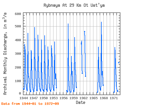
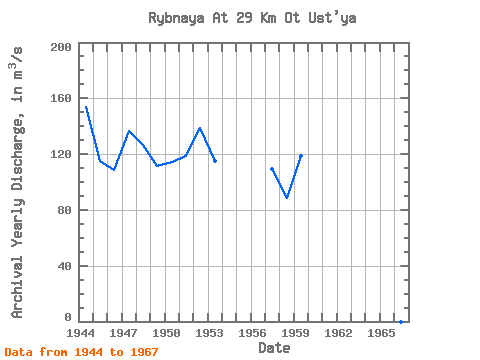
| Year | Jan | Feb | Mar | Apr | May | Jun | Jul | Aug | Sep | Oct | Nov | Dec | Annual | 1944 | 48.30 | 42.80 | 37.10 | 36.70 | 41.50 | 369.00 | 334.00 | 323.00 | 260.00 | 199.00 | 92.20 | 59.60 | 153.60 | 1945 | 49.20 | 34.80 | 30.30 | 26.50 | 134.00 | 448.00 | 182.00 | 129.00 | 134.00 | 107.00 | 62.30 | 45.80 | 115.24 | 1946 | 31.00 | 22.90 | 20.00 | 21.50 | 34.50 | 323.00 | 306.00 | 211.00 | 141.00 | 87.40 | 59.40 | 43.70 | 108.45 | 1947 | 30.00 | 24.10 | 21.40 | 25.30 | 59.40 | 491.00 | 335.00 | 186.00 | 188.00 | 159.00 | 75.00 | 48.10 | 136.86 | 1948 | 34.10 | 29.30 | 28.90 | 27.00 | 50.30 | 435.00 | 369.00 | 189.00 | 148.00 | 95.60 | 69.70 | 43.70 | 126.63 | 1949 | 38.40 | 34.80 | 26.90 | 22.70 | 67.60 | 402.00 | 252.00 | 195.00 | 131.00 | 94.20 | 40.00 | 32.10 | 111.39 | 1950 | 35.10 | 33.10 | 25.90 | 21.20 | 53.90 | 432.00 | 290.00 | 173.00 | 126.00 | 107.00 | 37.00 | 36.10 | 114.19 | 1951 | 37.30 | 33.50 | 27.40 | 23.50 | 71.60 | 349.00 | 301.00 | 209.00 | 166.00 | 97.70 | 60.60 | 47.10 | 118.64 | 1952 | 34.30 | 28.90 | 24.80 | 22.70 | 45.20 | 357.00 | 320.00 | 282.00 | 277.00 | 136.00 | 78.20 | 61.60 | 138.97 | 1953 | 44.00 | 35.80 | 31.10 | 27.90 | 116.00 | 386.00 | 197.00 | 115.00 | 145.00 | 152.00 | 82.20 | 50.00 | 115.17 | 1957 | 29.00 | 21.60 | 18.10 | 19.20 | 21.40 | 517.00 | 294.00 | 125.00 | 120.00 | 75.30 | 43.40 | 30.00 | 109.50 | 1958 | 22.10 | 21.20 | 17.30 | 18.30 | 17.30 | 280.00 | 190.00 | 143.00 | 172.00 | 94.70 | 53.60 | 36.90 | 88.87 | 1959 | 26.20 | 21.70 | 20.20 | 19.80 | 41.80 | 418.00 | 278.00 | 193.00 | 169.00 | 122.00 | 61.10 | 53.60 | 118.70 | 1961 | 370.00 | 393.00 | 192.00 | 155.00 | 1962 | 461.00 | 407.00 | 196.00 | 135.00 | 1966 | 18.00 | 21.50 | 157.00 | 348.00 | 204.00 | 179.00 | 121.00 | 56.50 | 51.90 | 1967 | 38.50 | 33.40 | 30.70 | 36.80 | 75.50 | 531.00 | 346.00 | 144.00 | 165.00 | 170.00 | 79.80 | 68.80 | 143.29 | 1971 | 19.20 | 16.60 | 29.90 | 345.00 | 307.00 | 220.00 | 177.00 | 115.00 | 67.40 | 51.50 | 1972 | 35.00 | 26.60 | 23.80 | 23.50 | 26.80 | 538.00 | 350.00 | 234.00 | 151.00 |
|---|
 Return to R-Arctic Net Home Page