|
|
|||||||||||||||||
| Point ID: 8378 | Downloads | Plots | Site Data | Code: 9459 |
|
|
|||||||||||||||||
| Download | |
|---|---|
| Site Descriptor Information | Site Time Series Data |
| Link to all available data | |
|
|
| View: | Statistics | Time Series |
| Units: | m3/s |
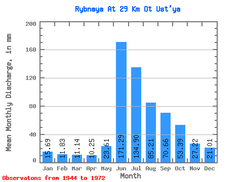
| Statistic | Jan | Feb | Mar | Apr | May | Jun | Jul | Aug | Sep | Oct | Nov | Dec | Annual |
|---|---|---|---|---|---|---|---|---|---|---|---|---|---|
| Mean | 15.69 | 11.93 | 11.13 | 10.24 | 23.61 | 171.29 | 134.88 | 85.20 | 70.66 | 53.39 | 27.23 | 21.00 | 632.21 |
| Standard Deviation | 3.35 | 2.62 | 2.48 | 2.48 | 14.31 | 39.78 | 28.27 | 22.85 | 17.64 | 15.03 | 6.70 | 4.70 | 87.89 |
| Min | 9.77 | 8.54 | 7.64 | 7.10 | 7.64 | 67.15 | 80.43 | 50.82 | 51.33 | 33.28 | 15.83 | 13.26 | 462.81 |
| Max | 21.74 | 17.23 | 16.39 | 15.74 | 59.22 | 230.12 | 179.86 | 142.74 | 118.48 | 87.94 | 39.44 | 30.40 | 799.94 |
| Coefficient of Variation | 0.21 | 0.22 | 0.22 | 0.24 | 0.61 | 0.23 | 0.21 | 0.27 | 0.25 | 0.28 | 0.25 | 0.22 | 0.14 |
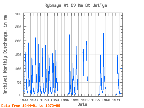
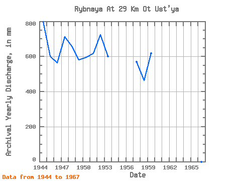
| Year | Jan | Feb | Mar | Apr | May | Jun | Jul | Aug | Sep | Oct | Nov | Dec | Annual | 1944 | 21.34 | 17.23 | 16.39 | 15.70 | 18.34 | 157.83 | 147.60 | 142.74 | 111.21 | 87.94 | 39.44 | 26.34 | 799.94 | 1945 | 21.74 | 14.01 | 13.39 | 11.34 | 59.22 | 191.62 | 80.43 | 57.01 | 57.31 | 47.28 | 26.65 | 20.24 | 600.17 | 1946 | 13.70 | 9.22 | 8.84 | 9.20 | 15.25 | 138.15 | 135.23 | 93.24 | 60.31 | 38.62 | 25.41 | 19.31 | 564.80 | 1947 | 13.26 | 9.70 | 9.46 | 10.82 | 26.25 | 210.01 | 148.04 | 82.20 | 80.41 | 70.26 | 32.08 | 21.26 | 712.75 | 1948 | 15.07 | 11.80 | 12.77 | 11.55 | 22.23 | 186.06 | 163.07 | 83.52 | 63.30 | 42.25 | 29.81 | 19.31 | 659.50 | 1949 | 16.97 | 14.01 | 11.89 | 9.71 | 29.87 | 171.94 | 111.36 | 86.17 | 56.03 | 41.63 | 17.11 | 14.19 | 580.12 | 1950 | 15.51 | 13.33 | 11.45 | 9.07 | 23.82 | 184.78 | 128.16 | 76.45 | 53.89 | 47.28 | 15.83 | 15.95 | 594.70 | 1951 | 16.48 | 13.49 | 12.11 | 10.05 | 31.64 | 149.28 | 133.02 | 92.36 | 71.00 | 43.17 | 25.92 | 20.81 | 617.88 | 1952 | 15.16 | 11.64 | 10.96 | 9.71 | 19.98 | 152.70 | 141.41 | 124.62 | 118.48 | 60.10 | 33.45 | 27.22 | 723.77 | 1953 | 19.44 | 14.41 | 13.74 | 11.93 | 51.26 | 165.10 | 87.06 | 50.82 | 62.02 | 67.17 | 35.16 | 22.10 | 599.78 | 1957 | 12.82 | 8.70 | 8.00 | 8.21 | 9.46 | 221.13 | 129.92 | 55.24 | 51.33 | 33.28 | 18.56 | 13.26 | 570.27 | 1958 | 9.77 | 8.54 | 7.64 | 7.83 | 7.64 | 119.76 | 83.96 | 63.19 | 73.57 | 41.85 | 22.93 | 16.31 | 462.81 | 1959 | 11.58 | 8.74 | 8.93 | 8.47 | 18.47 | 178.79 | 122.85 | 85.29 | 72.28 | 53.91 | 26.13 | 23.69 | 618.18 | 1961 | 158.26 | 173.67 | 84.85 | 66.30 | 1962 | 197.18 | 179.86 | 86.61 | 57.74 | 1966 | 7.70 | 9.50 | 67.15 | 153.79 | 90.15 | 76.56 | 53.47 | 24.17 | 22.93 | 1967 | 17.01 | 13.45 | 13.57 | 15.74 | 33.37 | 227.12 | 152.90 | 63.64 | 70.57 | 75.12 | 34.13 | 30.40 | 746.25 | 1971 | 8.48 | 7.10 | 13.21 | 147.56 | 135.67 | 97.22 | 75.71 | 50.82 | 28.83 | 22.76 | 1972 | 15.47 | 10.71 | 10.52 | 10.05 | 11.84 | 230.12 | 154.67 | 103.41 | 64.59 |
|---|
 Return to R-Arctic Net Home Page