|
|
|||||||||||||||||
| Point ID: 8378 | Downloads | Plots | Site Data | Code: 9459 |
|
|
|||||||||||||||||
| Download | |
|---|---|
| Site Descriptor Information | Site Time Series Data |
| Link to all available data | |
| View: | Time Series | All |
| Units: | mm |
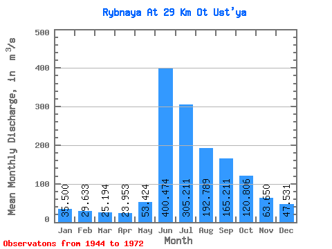
| Statistic | Jan | Feb | Mar | Apr | May | Jun | Jul | Aug | Sep | Oct | Nov | Dec | Annual |
|---|---|---|---|---|---|---|---|---|---|---|---|---|---|
| Mean | 35.50 | 29.63 | 25.19 | 23.95 | 53.42 | 400.47 | 305.21 | 192.79 | 165.21 | 120.81 | 63.65 | 47.53 | 121.39 |
| Standard Deviation | 7.59 | 6.49 | 5.61 | 5.80 | 32.39 | 93.00 | 63.98 | 51.70 | 41.25 | 34.02 | 15.66 | 10.63 | 16.88 |
| Min | 22.10 | 21.20 | 17.30 | 16.60 | 17.30 | 157.00 | 182.00 | 115.00 | 120.00 | 75.30 | 37.00 | 30.00 | 88.87 |
| Max | 49.20 | 42.80 | 37.10 | 36.80 | 134.00 | 538.00 | 407.00 | 323.00 | 277.00 | 199.00 | 92.20 | 68.80 | 153.60 |
| Coefficient of Variation | 0.21 | 0.22 | 0.22 | 0.24 | 0.61 | 0.23 | 0.21 | 0.27 | 0.25 | 0.28 | 0.25 | 0.22 | 0.14 |
 Return to R-Arctic Net Home Page