|
|
|||||||||||||||||
| Point ID: 7879 | Downloads | Plots | Site Data | Code: 3351 |
|
|
|||||||||||||||||
| Download | |
|---|---|
| Site Descriptor Information | Site Time Series Data |
| Link to all available data | |
|
|
| View: | Statistics | Time Series |
| Units: | mm |
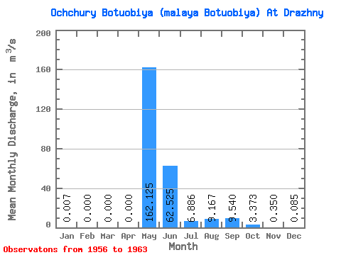
| Statistic | Jan | Feb | Mar | Apr | May | Jun | Jul | Aug | Sep | Oct | Nov | Dec | Annual |
|---|---|---|---|---|---|---|---|---|---|---|---|---|---|
| Mean | 0.01 | 0.00 | 0.00 | 0.00 | 162.12 | 62.52 | 6.89 | 9.17 | 9.54 | 3.37 | 0.35 | 0.09 | 22.61 |
| Standard Deviation | 0.01 | 0.00 | 0.00 | 0.00 | 59.07 | 35.41 | 9.38 | 9.09 | 10.08 | 3.08 | 0.28 | 0.15 | 5.76 |
| Min | 0.00 | 0.00 | 0.00 | 0.00 | 52.00 | 20.80 | 0.00 | 0.00 | 0.00 | 0.00 | 0.00 | 0.00 | 13.14 |
| Max | 0.03 | 0.00 | 0.00 | 0.00 | 222.00 | 118.00 | 25.90 | 21.00 | 28.50 | 8.76 | 0.69 | 0.36 | 28.59 |
| Coefficient of Variation | 1.71 | 0.36 | 0.57 | 1.36 | 0.99 | 1.06 | 0.91 | 0.79 | 1.72 | 0.26 |
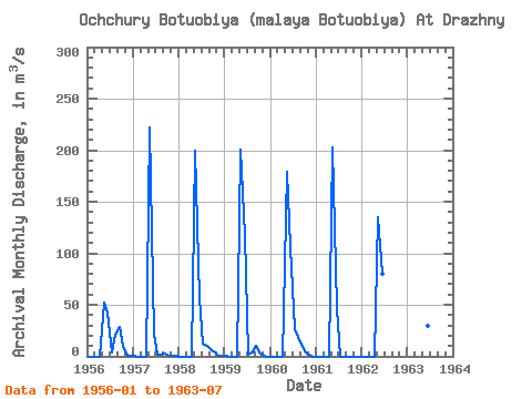
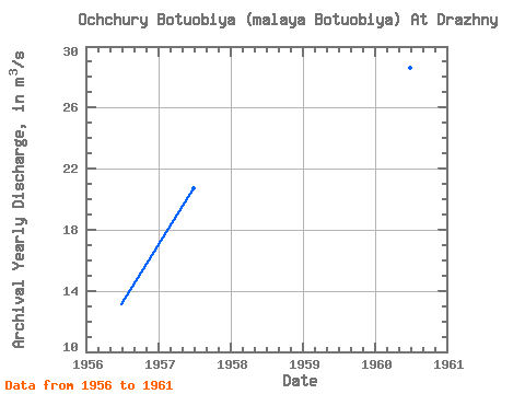
| Year | Jan | Feb | Mar | Apr | May | Jun | Jul | Aug | Sep | Oct | Nov | Dec | Annual | 1956 | 0.00 | 0.00 | 0.00 | 0.00 | 52.00 | 42.40 | 4.19 | 21.00 | 28.50 | 8.76 | 0.65 | 0.14 | 13.14 | 1957 | 0.02 | 0.00 | 0.00 | 0.00 | 222.00 | 20.80 | 1.16 | 1.32 | 2.30 | 0.92 | 0.14 | 0.01 | 20.72 | 1958 | 0.00 | 0.00 | 0.00 | 0.00 | 199.00 | 56.90 | 12.70 | 10.20 | 7.37 | 3.75 | 0.69 | 0.36 | 24.25 | 1959 | 0.03 | 0.00 | 0.00 | 0.00 | 201.00 | 118.00 | 1.91 | 3.58 | 10.10 | 2.76 | 0.38 | 0.00 | 28.15 | 1960 | 0.00 | 0.00 | 0.00 | 0.00 | 179.00 | 106.00 | 25.90 | 18.90 | 8.97 | 4.05 | 0.24 | 0.00 | 28.59 | 1961 | 0.00 | 0.00 | 0.00 | 0.00 | 203.00 | 46.60 | 0.00 | 0.00 | 0.00 | 0.00 | 0.00 | 0.00 | 20.80 | 1962 | 0.00 | 0.00 | 0.00 | 0.00 | 135.00 | 79.80 | 1963 | 106.00 | 29.70 | 2.34 |
|---|
 Return to R-Arctic Net Home Page