|
|
|||||||||||||||||
| Point ID: 7496 | Downloads | Plots | Site Data | Code: 70463 |
|
|
|||||||||||||||||
| Download | |
|---|---|
| Site Descriptor Information | Site Time Series Data |
| Link to all available data | |
| View: | Time Series | All |
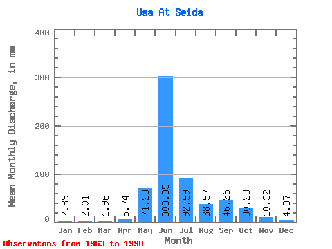
| Units: | m3/s |
| Statistic | Jan | Feb | Mar | Apr | May | Jun | Jul | Aug | Sep | Oct | Nov | Dec | Annual |
|---|---|---|---|---|---|---|---|---|---|---|---|---|---|
| Mean | 2.88 | 2.02 | 1.96 | 5.74 | 71.27 | 303.35 | 92.58 | 38.57 | 46.26 | 30.23 | 10.32 | 4.87 | 604.01 |
| Standard Deviation | 1.50 | 1.26 | 1.17 | 19.06 | 92.67 | 118.21 | 49.65 | 25.41 | 21.35 | 17.69 | 7.05 | 2.16 | 103.83 |
| Min | 0.26 | 0.17 | 0.18 | 0.09 | 1.25 | 25.00 | 35.14 | 11.93 | 16.80 | 5.66 | 2.26 | 0.58 | 406.70 |
| Max | 5.89 | 4.98 | 5.01 | 111.58 | 315.28 | 501.86 | 252.61 | 110.54 | 92.47 | 64.77 | 38.79 | 10.16 | 906.87 |
| Coefficient of Variation | 0.52 | 0.62 | 0.60 | 3.32 | 1.30 | 0.39 | 0.54 | 0.66 | 0.46 | 0.58 | 0.68 | 0.44 | 0.17 |
 Return to R-Arctic Net Home Page