|
|
|||||||||||||||||
| Point ID: 7496 | Downloads | Plots | Site Data | Code: 70463 |
|
|
|||||||||||||||||
| Download | |
|---|---|
| Site Descriptor Information | Site Time Series Data |
| Link to all available data | |
|
|
| View: | Statistics | Time Series |
| Units: | m3/s |
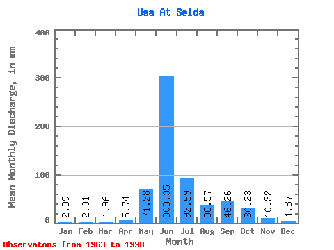
| Statistic | Jan | Feb | Mar | Apr | May | Jun | Jul | Aug | Sep | Oct | Nov | Dec | Annual |
|---|---|---|---|---|---|---|---|---|---|---|---|---|---|
| Mean | 2.88 | 2.02 | 1.96 | 5.74 | 71.27 | 303.35 | 92.58 | 38.57 | 46.26 | 30.23 | 10.32 | 4.87 | 604.01 |
| Standard Deviation | 1.50 | 1.26 | 1.17 | 19.06 | 92.67 | 118.21 | 49.65 | 25.41 | 21.35 | 17.69 | 7.05 | 2.16 | 103.83 |
| Min | 0.26 | 0.17 | 0.18 | 0.09 | 1.25 | 25.00 | 35.14 | 11.93 | 16.80 | 5.66 | 2.26 | 0.58 | 406.70 |
| Max | 5.89 | 4.98 | 5.01 | 111.58 | 315.28 | 501.86 | 252.61 | 110.54 | 92.47 | 64.77 | 38.79 | 10.16 | 906.87 |
| Coefficient of Variation | 0.52 | 0.62 | 0.60 | 3.32 | 1.30 | 0.39 | 0.54 | 0.66 | 0.46 | 0.58 | 0.68 | 0.44 | 0.17 |
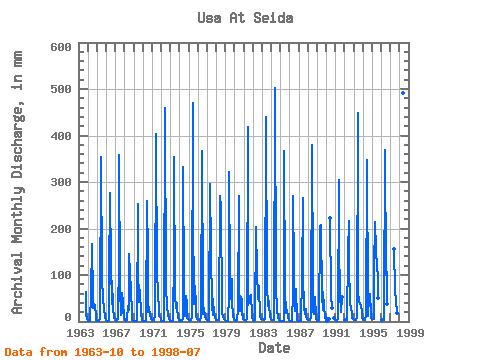
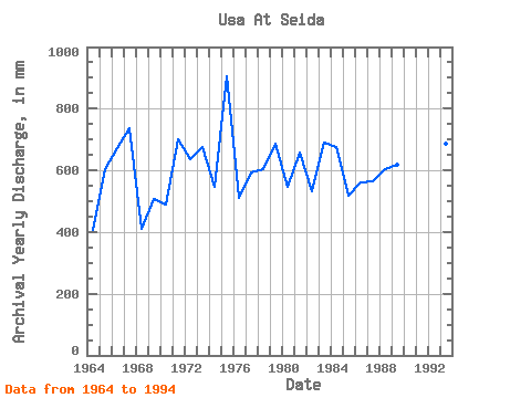
| Year | Jan | Feb | Mar | Apr | May | Jun | Jul | Aug | Sep | Oct | Nov | Dec | Annual | 1963 | 64.77 | 12.98 | 5.95 | 1964 | 1.98 | 1.13 | 0.99 | 0.84 | 60.02 | 167.28 | 54.32 | 30.96 | 38.60 | 34.95 | 12.46 | 3.21 | 406.70 | 1965 | 1.98 | 1.30 | 1.21 | 1.36 | 7.18 | 354.79 | 101.42 | 44.06 | 47.80 | 27.73 | 9.30 | 3.84 | 604.76 | 1966 | 2.58 | 1.41 | 1.01 | 0.74 | 96.86 | 275.75 | 124.78 | 38.56 | 86.40 | 31.34 | 6.69 | 6.70 | 672.94 | 1967 | 3.21 | 1.61 | 1.79 | 4.89 | 143.59 | 358.47 | 75.21 | 14.89 | 19.49 | 64.01 | 38.79 | 10.16 | 736.80 | 1968 | 3.99 | 2.11 | 2.20 | 2.44 | 34.00 | 25.00 | 149.28 | 105.41 | 66.73 | 18.97 | 2.89 | 0.58 | 409.57 | 1969 | 0.26 | 0.17 | 0.18 | 0.09 | 1.25 | 253.69 | 117.95 | 44.06 | 67.47 | 14.57 | 4.71 | 3.40 | 509.31 | 1970 | 1.08 | 0.41 | 0.31 | 0.62 | 1.87 | 259.20 | 145.68 | 22.03 | 31.07 | 12.44 | 7.96 | 4.79 | 488.49 | 1971 | 2.26 | 1.25 | 0.95 | 1.35 | 16.43 | 402.59 | 91.36 | 80.72 | 72.43 | 13.22 | 8.88 | 5.03 | 699.92 | 1972 | 2.07 | 1.09 | 1.23 | 2.02 | 2.60 | 459.57 | 70.84 | 41.02 | 30.15 | 16.56 | 4.49 | 1.51 | 638.09 | 1973 | 1.17 | 0.68 | 0.65 | 1.07 | 147.76 | 354.79 | 59.83 | 29.06 | 39.34 | 27.73 | 8.99 | 3.82 | 676.02 | 1974 | 2.45 | 1.39 | 1.10 | 1.84 | 7.24 | 332.73 | 76.54 | 13.22 | 54.05 | 41.02 | 7.43 | 4.69 | 546.99 | 1975 | 3.67 | 2.49 | 2.05 | 2.44 | 8.21 | 470.60 | 248.81 | 39.70 | 75.37 | 36.47 | 9.67 | 5.18 | 906.87 | 1976 | 2.85 | 2.04 | 1.79 | 2.21 | 8.57 | 365.82 | 54.13 | 15.76 | 29.41 | 11.07 | 6.30 | 5.20 | 509.46 | 1977 | 3.31 | 1.58 | 1.76 | 2.48 | 305.79 | 152.40 | 35.14 | 13.69 | 48.90 | 16.83 | 8.31 | 6.00 | 592.56 | 1978 | 4.03 | 3.29 | 2.47 | 2.61 | 3.10 | 270.23 | 252.61 | 29.25 | 19.49 | 10.90 | 5.15 | 2.45 | 604.71 | 1979 | 1.03 | 0.39 | 0.32 | 0.41 | 61.54 | 321.70 | 97.81 | 49.76 | 92.47 | 43.87 | 10.83 | 5.83 | 687.57 | 1980 | 3.06 | 1.82 | 2.20 | 2.54 | 25.07 | 270.23 | 93.06 | 23.55 | 53.68 | 45.96 | 18.75 | 5.26 | 546.84 | 1981 | 4.42 | 3.37 | 2.47 | 2.11 | 7.88 | 419.13 | 37.61 | 42.35 | 51.66 | 59.45 | 16.55 | 6.99 | 658.54 | 1982 | 2.77 | 1.94 | 2.51 | 5.09 | 208.92 | 106.62 | 54.89 | 49.95 | 77.39 | 11.11 | 6.78 | 5.95 | 530.92 | 1983 | 5.81 | 4.59 | 4.04 | 3.93 | 6.65 | 439.35 | 80.15 | 33.43 | 55.33 | 34.19 | 11.82 | 6.04 | 690.12 | 1984 | 4.80 | 3.31 | 3.13 | 3.73 | 14.02 | 501.86 | 81.29 | 19.18 | 24.82 | 10.43 | 2.26 | 1.07 | 675.56 | 1985 | 0.56 | 0.35 | 0.47 | 0.28 | 1.92 | 367.66 | 68.75 | 19.18 | 19.67 | 24.88 | 8.25 | 2.75 | 518.43 | 1986 | 1.73 | 1.18 | 0.83 | 1.28 | 64.39 | 270.23 | 117.57 | 23.93 | 68.94 | 5.66 | 2.72 | 1.24 | 560.95 | 1987 | 0.93 | 0.94 | 1.20 | 1.67 | 99.90 | 264.71 | 101.80 | 33.05 | 17.06 | 27.54 | 9.89 | 6.21 | 564.43 | 1988 | 3.44 | 2.94 | 2.92 | 2.61 | 10.56 | 380.53 | 90.22 | 22.41 | 16.80 | 54.70 | 9.43 | 5.17 | 604.56 | 1989 | 2.20 | 1.65 | 2.45 | 2.43 | 208.92 | 207.73 | 56.03 | 25.64 | 63.24 | 31.34 | 12.17 | 6.86 | 618.99 | 1990 | 1.28 | 2.05 | 6.38 | 222.43 | 57.17 | 29.82 | 28.31 | 7.46 | 4.46 | 1991 | 3.93 | 1.96 | 2.22 | 4.71 | 315.28 | 159.20 | 63.44 | 20.32 | 53.13 | 1992 | 3.89 | 3.10 | 3.02 | 152.89 | 216.92 | 130.10 | 39.51 | 28.13 | 18.84 | 7.63 | 4.94 | 1993 | 3.84 | 3.10 | 3.12 | 3.22 | 6.97 | 448.55 | 64.39 | 45.77 | 37.69 | 34.19 | 21.88 | 7.98 | 685.42 | 1994 | 5.28 | 3.58 | 3.74 | 4.65 | 10.86 | 347.44 | 36.47 | 11.93 | 50.74 | 62.11 | 18.38 | 7.65 | 566.81 | 1995 | 5.89 | 4.98 | 5.01 | 111.58 | 220.32 | 153.50 | 121.75 | 99.71 | 51.10 | 1996 | 3.58 | 3.29 | 2.87 | 20.13 | 369.50 | 104.27 | 110.54 | 38.05 | 1997 | 156.25 | 68.19 | 48.81 | 17.89 | 1998 | 490.83 | 57.36 |
|---|
 Return to R-Arctic Net Home Page