|
|
|||||||||||||||||
| Point ID: 7496 | Downloads | Plots | Site Data | Code: 70463 |
|
|
|||||||||||||||||
| Download | |
|---|---|
| Site Descriptor Information | Site Time Series Data |
| Link to all available data | |
| View: | Time Series | All |
| Units: | mm |
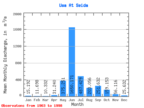
| Statistic | Jan | Feb | Mar | Apr | May | Jun | Jul | Aug | Sep | Oct | Nov | Dec | Annual |
|---|---|---|---|---|---|---|---|---|---|---|---|---|---|
| Mean | 15.19 | 11.70 | 10.33 | 31.24 | 375.25 | 1650.17 | 487.43 | 203.06 | 251.63 | 159.15 | 56.12 | 25.63 | 269.85 |
| Standard Deviation | 7.93 | 7.29 | 6.17 | 103.69 | 487.93 | 643.03 | 261.40 | 133.78 | 116.15 | 93.12 | 38.37 | 11.39 | 46.39 |
| Min | 1.36 | 1.00 | 0.95 | 0.47 | 6.57 | 136.00 | 185.00 | 62.80 | 91.40 | 29.80 | 12.30 | 3.07 | 181.70 |
| Max | 31.00 | 28.80 | 26.40 | 607.00 | 1660.00 | 2730.00 | 1330.00 | 582.00 | 503.00 | 341.00 | 211.00 | 53.50 | 405.16 |
| Coefficient of Variation | 0.52 | 0.62 | 0.60 | 3.32 | 1.30 | 0.39 | 0.54 | 0.66 | 0.46 | 0.58 | 0.68 | 0.44 | 0.17 |
 Return to R-Arctic Net Home Page