|
|
|||||||||||||||||
| Point ID: 7496 | Downloads | Plots | Site Data | Code: 70463 |
|
|
|||||||||||||||||
| Download | |
|---|---|
| Site Descriptor Information | Site Time Series Data |
| Link to all available data | |
|
|
| View: | Statistics | Time Series |
| Units: | mm |
| Statistic | Jan | Feb | Mar | Apr | May | Jun | Jul | Aug | Sep | Oct | Nov | Dec | Annual |
|---|---|---|---|---|---|---|---|---|---|---|---|---|---|
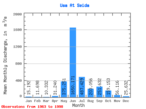
| Mean | 15.19 | 11.70 | 10.33 | 31.24 | 375.25 | 1650.17 | 487.43 | 203.06 | 251.63 | 159.15 | 56.12 | 25.63 | 269.85 |
| Standard Deviation | 7.93 | 7.29 | 6.17 | 103.69 | 487.93 | 643.03 | 261.40 | 133.78 | 116.15 | 93.12 | 38.37 | 11.39 | 46.39 |
| Min | 1.36 | 1.00 | 0.95 | 0.47 | 6.57 | 136.00 | 185.00 | 62.80 | 91.40 | 29.80 | 12.30 | 3.07 | 181.70 |
| Max | 31.00 | 28.80 | 26.40 | 607.00 | 1660.00 | 2730.00 | 1330.00 | 582.00 | 503.00 | 341.00 | 211.00 | 53.50 | 405.16 |
| Coefficient of Variation | 0.52 | 0.62 | 0.60 | 3.32 | 1.30 | 0.39 | 0.54 | 0.66 | 0.46 | 0.58 | 0.68 | 0.44 | 0.17 |
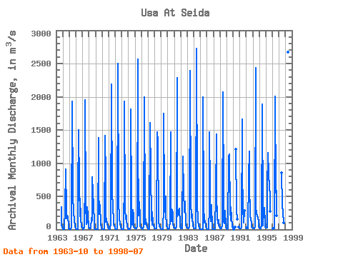
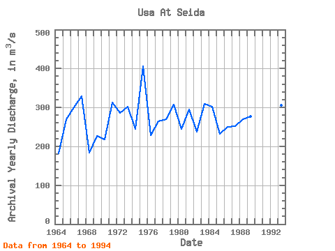
| Year | Jan | Feb | Mar | Apr | May | Jun | Jul | Aug | Sep | Oct | Nov | Dec | Annual | 1963 | 341.00 | 70.60 | 31.30 | 1964 | 10.40 | 6.55 | 5.19 | 4.59 | 316.00 | 910.00 | 286.00 | 163.00 | 210.00 | 184.00 | 67.80 | 16.90 | 181.70 | 1965 | 10.40 | 7.49 | 6.35 | 7.41 | 37.80 | 1930.00 | 534.00 | 232.00 | 260.00 | 146.00 | 50.60 | 20.20 | 270.19 | 1966 | 13.60 | 8.14 | 5.31 | 4.02 | 510.00 | 1500.00 | 657.00 | 203.00 | 470.00 | 165.00 | 36.40 | 35.30 | 300.65 | 1967 | 16.90 | 9.31 | 9.43 | 26.60 | 756.00 | 1950.00 | 396.00 | 78.40 | 106.00 | 337.00 | 211.00 | 53.50 | 329.18 | 1968 | 21.00 | 12.20 | 11.60 | 13.30 | 179.00 | 136.00 | 786.00 | 555.00 | 363.00 | 99.90 | 15.70 | 3.07 | 182.98 | 1969 | 1.36 | 1.00 | 0.95 | 0.47 | 6.57 | 1380.00 | 621.00 | 232.00 | 367.00 | 76.70 | 25.60 | 17.90 | 227.55 | 1970 | 5.71 | 2.35 | 1.62 | 3.35 | 9.86 | 1410.00 | 767.00 | 116.00 | 169.00 | 65.50 | 43.30 | 25.20 | 218.24 | 1971 | 11.90 | 7.22 | 5.02 | 7.36 | 86.50 | 2190.00 | 481.00 | 425.00 | 394.00 | 69.60 | 48.30 | 26.50 | 312.70 | 1972 | 10.90 | 6.31 | 6.47 | 11.00 | 13.70 | 2500.00 | 373.00 | 216.00 | 164.00 | 87.20 | 24.40 | 7.93 | 285.08 | 1973 | 6.14 | 3.93 | 3.41 | 5.81 | 778.00 | 1930.00 | 315.00 | 153.00 | 214.00 | 146.00 | 48.90 | 20.10 | 302.02 | 1974 | 12.90 | 8.02 | 5.79 | 10.00 | 38.10 | 1810.00 | 403.00 | 69.60 | 294.00 | 216.00 | 40.40 | 24.70 | 244.38 | 1975 | 19.30 | 14.40 | 10.80 | 13.30 | 43.20 | 2560.00 | 1310.00 | 209.00 | 410.00 | 192.00 | 52.60 | 27.30 | 405.16 | 1976 | 15.00 | 11.80 | 9.42 | 12.00 | 45.10 | 1990.00 | 285.00 | 83.00 | 160.00 | 58.30 | 34.30 | 27.40 | 227.61 | 1977 | 17.40 | 9.16 | 9.27 | 13.50 | 1610.00 | 829.00 | 185.00 | 72.10 | 266.00 | 88.60 | 45.20 | 31.60 | 264.74 | 1978 | 21.20 | 19.00 | 13.00 | 14.20 | 16.30 | 1470.00 | 1330.00 | 154.00 | 106.00 | 57.40 | 28.00 | 12.90 | 270.17 | 1979 | 5.43 | 2.25 | 1.68 | 2.25 | 324.00 | 1750.00 | 515.00 | 262.00 | 503.00 | 231.00 | 58.90 | 30.70 | 307.18 | 1980 | 16.10 | 10.50 | 11.60 | 13.80 | 132.00 | 1470.00 | 490.00 | 124.00 | 292.00 | 242.00 | 102.00 | 27.70 | 244.31 | 1981 | 23.30 | 19.50 | 13.00 | 11.50 | 41.50 | 2280.00 | 198.00 | 223.00 | 281.00 | 313.00 | 90.00 | 36.80 | 294.22 | 1982 | 14.60 | 11.20 | 13.20 | 27.70 | 1100.00 | 580.00 | 289.00 | 263.00 | 421.00 | 58.50 | 36.90 | 31.30 | 237.20 | 1983 | 30.60 | 26.50 | 21.30 | 21.40 | 35.00 | 2390.00 | 422.00 | 176.00 | 301.00 | 180.00 | 64.30 | 31.80 | 308.32 | 1984 | 25.30 | 19.10 | 16.50 | 20.30 | 73.80 | 2730.00 | 428.00 | 101.00 | 135.00 | 54.90 | 12.30 | 5.63 | 301.82 | 1985 | 2.93 | 2.00 | 2.46 | 1.52 | 10.10 | 2000.00 | 362.00 | 101.00 | 107.00 | 131.00 | 44.90 | 14.50 | 231.62 | 1986 | 9.10 | 6.81 | 4.37 | 6.94 | 339.00 | 1470.00 | 619.00 | 126.00 | 375.00 | 29.80 | 14.80 | 6.55 | 250.61 | 1987 | 4.89 | 5.43 | 6.33 | 9.09 | 526.00 | 1440.00 | 536.00 | 174.00 | 92.80 | 145.00 | 53.80 | 32.70 | 252.17 | 1988 | 18.10 | 17.00 | 15.40 | 14.20 | 55.60 | 2070.00 | 475.00 | 118.00 | 91.40 | 288.00 | 51.30 | 27.20 | 270.10 | 1989 | 11.60 | 9.56 | 12.90 | 13.20 | 1100.00 | 1130.00 | 295.00 | 135.00 | 344.00 | 165.00 | 66.20 | 36.10 | 276.55 | 1990 | 7.42 | 10.80 | 34.70 | 1210.00 | 301.00 | 157.00 | 154.00 | 40.60 | 23.50 | 1991 | 20.70 | 11.30 | 11.70 | 25.60 | 1660.00 | 866.00 | 334.00 | 107.00 | 289.00 | 1992 | 22.50 | 16.30 | 16.40 | 805.00 | 1180.00 | 685.00 | 208.00 | 153.00 | 99.20 | 41.50 | 26.00 | 1993 | 20.20 | 17.90 | 16.40 | 17.50 | 36.70 | 2440.00 | 339.00 | 241.00 | 205.00 | 180.00 | 119.00 | 42.00 | 306.23 | 1994 | 27.80 | 20.70 | 19.70 | 25.30 | 57.20 | 1890.00 | 192.00 | 62.80 | 276.00 | 327.00 | 100.00 | 40.30 | 253.23 | 1995 | 31.00 | 28.80 | 26.40 | 607.00 | 1160.00 | 835.00 | 641.00 | 525.00 | 278.00 | 1996 | 20.70 | 17.30 | 15.60 | 106.00 | 2010.00 | 549.00 | 582.00 | 207.00 | 1997 | 850.00 | 359.00 | 257.00 | 97.30 | 1998 | 2670.00 | 302.00 |
|---|
 Return to R-Arctic Net Home Page