|
|
|||||||||||||||||
| Point ID: 6987 | Downloads | Plots | Site Data | Code: 11199 |
|
|
|||||||||||||||||
| Download | |
|---|---|
| Site Descriptor Information | Site Time Series Data |
| Link to all available data | |
|
|
| View: | Statistics | Time Series |
| Units: | mm |
| Statistic | Jan | Feb | Mar | Apr | May | Jun | Jul | Aug | Sep | Oct | Nov | Dec | Annual |
|---|---|---|---|---|---|---|---|---|---|---|---|---|---|
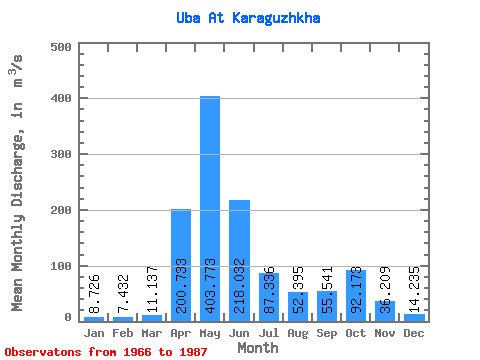
| Mean | 8.73 | 7.43 | 11.14 | 200.73 | 403.77 | 218.03 | 87.34 | 52.40 | 55.54 | 92.17 | 36.21 | 14.23 | 97.87 |
| Standard Deviation | 2.73 | 2.20 | 6.95 | 64.00 | 126.27 | 108.42 | 41.18 | 29.93 | 37.36 | 53.80 | 13.37 | 6.07 | 21.59 |
| Min | 4.97 | 4.60 | 6.11 | 98.40 | 194.00 | 69.20 | 24.30 | 16.60 | 18.60 | 20.40 | 15.20 | 4.11 | 63.82 |
| Max | 17.30 | 14.10 | 39.60 | 379.00 | 725.00 | 473.00 | 189.00 | 109.00 | 176.00 | 218.00 | 64.20 | 28.70 | 145.21 |
| Coefficient of Variation | 0.31 | 0.30 | 0.62 | 0.32 | 0.31 | 0.50 | 0.47 | 0.57 | 0.67 | 0.58 | 0.37 | 0.43 | 0.22 |
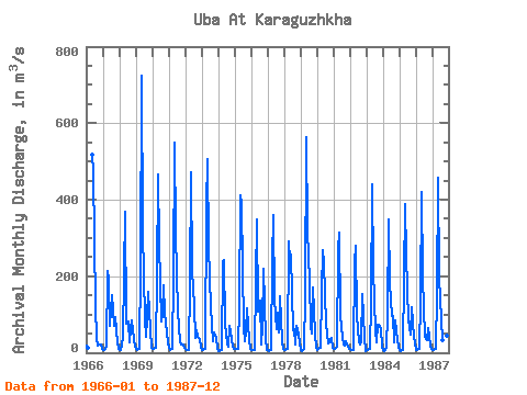
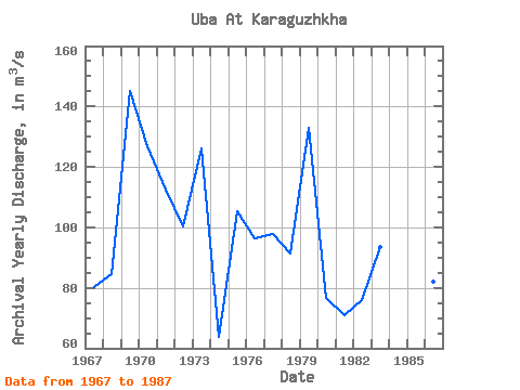
| Year | Jan | Feb | Mar | Apr | May | Jun | Jul | Aug | Sep | Oct | Nov | Dec | Annual | 1966 | 17.30 | 14.10 | 517.00 | 473.00 | 122.00 | 37.10 | 19.50 | 21.70 | 22.30 | 9.96 | 1967 | 6.77 | 6.93 | 14.70 | 214.00 | 194.00 | 69.20 | 151.00 | 109.00 | 69.30 | 92.20 | 25.90 | 9.30 | 80.19 | 1968 | 8.54 | 7.61 | 39.60 | 208.00 | 369.00 | 76.70 | 82.20 | 25.90 | 60.70 | 83.60 | 36.40 | 17.10 | 84.61 | 1969 | 9.16 | 7.16 | 9.55 | 222.00 | 725.00 | 317.00 | 88.50 | 42.10 | 90.20 | 158.00 | 60.30 | 13.50 | 145.21 | 1970 | 11.30 | 10.60 | 12.70 | 196.00 | 466.00 | 286.00 | 83.00 | 102.00 | 176.00 | 104.00 | 52.60 | 23.90 | 127.01 | 1971 | 13.40 | 6.72 | 8.92 | 199.00 | 549.00 | 315.00 | 105.00 | 70.00 | 28.30 | 20.40 | 22.80 | 12.10 | 112.55 | 1972 | 9.96 | 8.17 | 7.89 | 180.00 | 473.00 | 215.00 | 123.00 | 37.70 | 57.90 | 41.20 | 34.80 | 15.80 | 100.37 | 1973 | 7.39 | 6.03 | 9.43 | 379.00 | 507.00 | 278.00 | 119.00 | 74.10 | 30.20 | 53.40 | 37.90 | 13.40 | 126.24 | 1974 | 4.97 | 5.30 | 6.93 | 237.00 | 241.00 | 76.30 | 24.30 | 16.60 | 69.80 | 57.10 | 15.20 | 11.30 | 63.82 | 1975 | 9.60 | 9.39 | 10.80 | 127.00 | 411.00 | 389.00 | 65.80 | 29.50 | 52.90 | 116.00 | 33.90 | 9.95 | 105.40 | 1976 | 8.44 | 7.36 | 7.11 | 189.00 | 349.00 | 108.00 | 137.00 | 22.20 | 68.50 | 218.00 | 34.80 | 7.52 | 96.41 | 1977 | 8.30 | 5.30 | 6.84 | 242.00 | 361.00 | 140.00 | 62.10 | 104.00 | 52.40 | 149.00 | 30.60 | 11.10 | 97.72 | 1978 | 6.01 | 6.22 | 10.70 | 291.00 | 240.00 | 256.00 | 58.60 | 62.20 | 22.00 | 70.40 | 47.60 | 23.70 | 91.20 | 1979 | 7.91 | 5.13 | 9.56 | 147.00 | 564.00 | 321.00 | 189.00 | 69.60 | 51.30 | 170.00 | 50.10 | 12.80 | 133.12 | 1980 | 5.79 | 9.22 | 12.00 | 160.00 | 268.00 | 235.00 | 76.70 | 46.70 | 25.00 | 28.40 | 38.30 | 14.20 | 76.61 | 1981 | 10.30 | 9.48 | 14.70 | 272.00 | 313.00 | 97.30 | 39.60 | 22.40 | 18.60 | 29.30 | 15.50 | 9.21 | 70.95 | 1982 | 9.85 | 8.58 | 7.69 | 235.00 | 281.00 | 98.20 | 26.80 | 20.50 | 26.50 | 154.00 | 38.10 | 4.11 | 75.86 | 1983 | 6.91 | 6.13 | 9.55 | 130.00 | 440.00 | 219.00 | 57.00 | 28.30 | 74.30 | 72.60 | 64.20 | 15.50 | 93.62 | 1984 | 7.64 | 4.60 | 11.50 | 98.40 | 349.00 | 182.00 | 95.80 | 97.00 | 27.20 | 84.10 | 32.70 | 17.00 | 83.91 | 1985 | 8.11 | 5.18 | 6.11 | 196.00 | 389.00 | 253.00 | 85.40 | 66.20 | 47.50 | 118.00 | 40.50 | 23.30 | 103.19 | 1986 | 6.29 | 6.91 | 8.79 | 140.00 | 421.00 | 197.00 | 42.90 | 35.70 | 32.80 | 64.40 | 18.50 | 9.73 | 82.00 | 1987 | 8.03 | 7.38 | 8.80 | 153.00 | 456.00 | 195.00 | 86.70 | 33.90 | 121.00 | 122.00 | 43.60 | 28.70 | 105.34 |
|---|
 Return to R-Arctic Net Home Page