|
|
|||||||||||||||||
| Point ID: 6758 | Downloads | Plots | Site Data | Code: 10233 |
|
|
|||||||||||||||||
| Download | |
|---|---|
| Site Descriptor Information | Site Time Series Data |
| Link to all available data | |
|
|
| View: | Statistics | Time Series |
| Units: | mm |
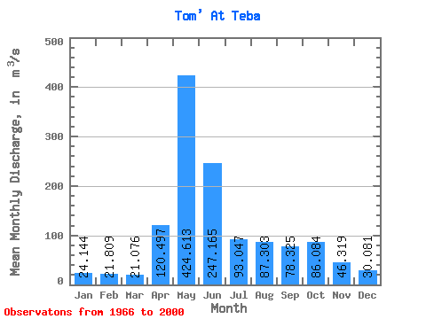
| Statistic | Jan | Feb | Mar | Apr | May | Jun | Jul | Aug | Sep | Oct | Nov | Dec | Annual |
|---|---|---|---|---|---|---|---|---|---|---|---|---|---|
| Mean | 24.14 | 21.81 | 21.08 | 120.50 | 424.61 | 247.16 | 93.05 | 87.30 | 78.33 | 86.08 | 46.32 | 30.08 | 106.61 |
| Standard Deviation | 10.97 | 9.64 | 9.12 | 74.13 | 120.79 | 147.47 | 43.55 | 41.04 | 37.37 | 41.39 | 17.45 | 12.59 | 25.71 |
| Min | 5.62 | 3.99 | 9.73 | 24.60 | 147.00 | 58.20 | 38.30 | 35.20 | 34.20 | 34.70 | 20.40 | 15.30 | 42.72 |
| Max | 49.50 | 46.30 | 47.30 | 410.00 | 655.00 | 686.00 | 218.00 | 195.00 | 168.00 | 191.00 | 95.30 | 68.50 | 150.28 |
| Coefficient of Variation | 0.45 | 0.44 | 0.43 | 0.61 | 0.28 | 0.60 | 0.47 | 0.47 | 0.48 | 0.48 | 0.38 | 0.42 | 0.24 |
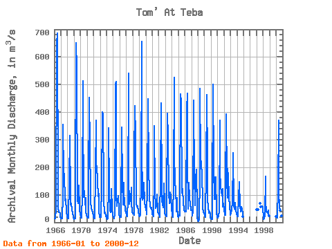
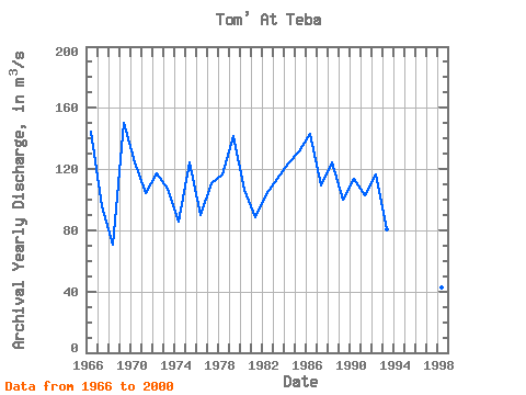
| Year | Jan | Feb | Mar | Apr | May | Jun | Jul | Aug | Sep | Oct | Nov | Dec | Annual | 1966 | 13.90 | 12.80 | 12.70 | 48.00 | 648.00 | 686.00 | 131.00 | 54.90 | 36.80 | 37.00 | 33.50 | 20.00 | 144.55 | 1967 | 14.50 | 15.30 | 14.50 | 96.50 | 355.00 | 167.00 | 177.00 | 80.10 | 82.80 | 85.00 | 38.10 | 19.20 | 95.42 | 1968 | 14.80 | 12.60 | 14.70 | 151.00 | 314.00 | 88.00 | 65.10 | 70.20 | 47.30 | 34.70 | 22.50 | 15.30 | 70.85 | 1969 | 12.00 | 14.40 | 13.90 | 96.90 | 650.00 | 557.00 | 81.10 | 69.40 | 97.50 | 135.00 | 49.80 | 26.30 | 150.28 | 1970 | 20.10 | 17.10 | 16.90 | 103.00 | 514.00 | 397.00 | 92.60 | 113.00 | 64.90 | 88.40 | 37.20 | 25.90 | 124.17 | 1971 | 19.40 | 16.70 | 15.60 | 137.00 | 453.00 | 275.00 | 108.00 | 75.10 | 51.20 | 44.70 | 35.30 | 20.30 | 104.28 | 1972 | 21.00 | 14.50 | 13.50 | 172.00 | 371.00 | 208.00 | 205.00 | 149.00 | 93.60 | 105.00 | 37.70 | 17.80 | 117.34 | 1973 | 20.00 | 18.30 | 19.50 | 131.00 | 401.00 | 390.00 | 113.00 | 78.80 | 34.40 | 36.10 | 20.40 | 23.90 | 107.20 | 1974 | 15.40 | 11.50 | 14.10 | 129.00 | 343.00 | 123.00 | 42.00 | 37.30 | 122.00 | 118.00 | 48.20 | 27.20 | 85.89 | 1975 | 19.80 | 15.40 | 13.00 | 29.60 | 502.00 | 511.00 | 95.60 | 58.00 | 78.00 | 97.00 | 42.30 | 29.90 | 124.30 | 1976 | 20.00 | 19.60 | 18.80 | 55.80 | 345.00 | 153.00 | 65.10 | 144.00 | 101.00 | 76.60 | 44.60 | 36.70 | 90.02 | 1977 | 27.40 | 24.30 | 20.70 | 82.40 | 541.00 | 161.00 | 66.80 | 83.90 | 84.30 | 126.00 | 74.80 | 35.50 | 110.67 | 1978 | 30.60 | 31.20 | 27.00 | 236.00 | 422.00 | 312.00 | 84.10 | 69.50 | 55.50 | 59.80 | 42.30 | 23.70 | 116.14 | 1979 | 22.80 | 22.50 | 25.70 | 147.00 | 655.00 | 282.00 | 81.10 | 88.40 | 96.10 | 144.00 | 77.70 | 54.20 | 141.38 | 1980 | 49.50 | 34.50 | 29.50 | 124.00 | 447.00 | 205.00 | 98.00 | 91.90 | 57.80 | 51.00 | 54.30 | 34.90 | 106.45 | 1981 | 30.00 | 25.20 | 21.80 | 167.00 | 351.00 | 117.00 | 51.00 | 57.90 | 73.80 | 101.00 | 36.50 | 30.70 | 88.58 | 1982 | 25.80 | 20.90 | 17.90 | 164.00 | 433.00 | 134.00 | 77.50 | 67.20 | 53.60 | 143.00 | 69.00 | 33.40 | 103.28 | 1983 | 26.60 | 23.20 | 21.60 | 69.90 | 396.00 | 313.00 | 105.00 | 68.10 | 92.50 | 108.00 | 95.30 | 45.80 | 113.75 | 1984 | 34.10 | 26.70 | 18.60 | 148.00 | 525.00 | 260.00 | 137.00 | 129.00 | 38.60 | 90.20 | 59.50 | 21.10 | 123.98 | 1985 | 19.70 | 27.50 | 23.70 | 97.70 | 466.00 | 439.00 | 107.00 | 129.00 | 113.00 | 74.50 | 44.90 | 39.70 | 131.81 | 1986 | 39.90 | 38.00 | 38.10 | 410.00 | 468.00 | 234.00 | 49.40 | 144.00 | 92.50 | 83.70 | 72.20 | 43.80 | 142.80 | 1987 | 42.90 | 43.90 | 24.50 | 40.10 | 444.00 | 157.00 | 83.40 | 60.50 | 160.00 | 191.00 | 47.50 | 17.30 | 109.34 | 1988 | 5.62 | 3.99 | 9.73 | 167.00 | 485.00 | 228.00 | 218.00 | 168.00 | 83.00 | 53.20 | 36.30 | 33.10 | 124.25 | 1989 | 22.80 | 17.90 | 18.40 | 191.00 | 463.00 | 223.00 | 84.90 | 56.50 | 35.00 | 38.80 | 28.10 | 16.50 | 99.66 | 1990 | 13.50 | 11.50 | 12.30 | 74.40 | 500.00 | 199.00 | 85.10 | 84.60 | 164.00 | 165.00 | 33.10 | 19.20 | 113.47 | 1991 | 16.40 | 17.70 | 20.10 | 41.90 | 369.00 | 191.00 | 123.00 | 115.00 | 95.70 | 121.00 | 55.50 | 68.50 | 102.90 | 1992 | 45.30 | 27.10 | 26.10 | 119.00 | 392.00 | 157.00 | 88.20 | 195.00 | 168.00 | 93.70 | 56.70 | 31.50 | 116.63 | 1993 | 26.90 | 31.90 | 45.90 | 73.70 | 226.00 | 253.00 | 61.80 | 50.00 | 46.90 | 72.40 | 40.60 | 34.40 | 80.29 | 1994 | 20.20 | 22.40 | 29.00 | 85.90 | 147.00 | 58.20 | 38.30 | 39.50 | 55.40 | 46.20 | 33.00 | 22.10 | 49.77 | 1997 | 47.40 | 46.30 | 47.30 | 69.30 | 56.20 | 55.40 | 59.80 | 53.90 | 1998 | 13.00 | 12.40 | 13.50 | 24.60 | 166.00 | 74.90 | 39.60 | 35.20 | 34.20 | 43.20 | 32.50 | 23.50 | 42.72 | 2000 | 21.30 | 20.60 | 15.80 | 122.00 | 371.00 | 109.00 | 53.50 | 43.40 | 40.80 | 36.10 | 23.00 | 17.30 | 72.82 |
|---|
 Return to R-Arctic Net Home Page