|
|
|||||||||||||||||
| Point ID: 6638 | Downloads | Plots | Site Data | Code: 9476 |
|
|
|||||||||||||||||
| Download | |
|---|---|
| Site Descriptor Information | Site Time Series Data |
| Link to all available data | |
| View: | Time Series | All |
| Units: | m3/s |
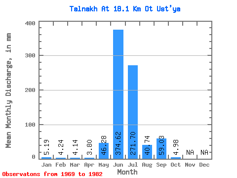
| Statistic | Jan | Feb | Mar | Apr | May | Jun | Jul | Aug | Sep | Oct | Nov | Dec | Annual |
|---|---|---|---|---|---|---|---|---|---|---|---|---|---|
| Mean | 5.19 | 4.28 | 4.14 | 3.80 | 46.27 | 374.62 | 271.66 | 40.73 | 59.03 | 4.98 | |||
| Standard Deviation | 32.72 | 232.31 | 129.76 | 26.77 | 36.89 | 6.07 | |||||||
| Min | 5.19 | 4.28 | 4.14 | 3.80 | 23.14 | 130.28 | 38.56 | 12.62 | 19.68 | 1.05 | |||
| Max | 5.19 | 4.28 | 4.14 | 3.80 | 69.40 | 875.31 | 456.38 | 97.45 | 137.74 | 14.02 | |||
| Coefficient of Variation | 0.71 | 0.62 | 0.48 | 0.66 | 0.62 | 1.22 |
 Return to R-Arctic Net Home Page