|
|
|||||||||||||||||
| Point ID: 6638 | Downloads | Plots | Site Data | Code: 9476 |
|
|
|||||||||||||||||
| Download | |
|---|---|
| Site Descriptor Information | Site Time Series Data |
| Link to all available data | |
|
|
| View: | Statistics | Time Series |
| Units: | m3/s |
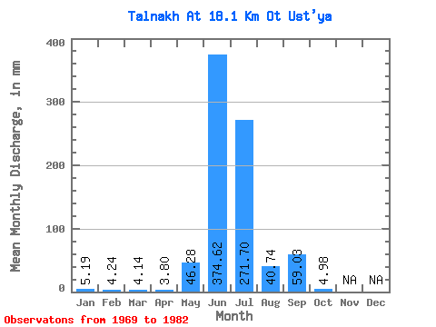
| Statistic | Jan | Feb | Mar | Apr | May | Jun | Jul | Aug | Sep | Oct | Nov | Dec | Annual |
|---|---|---|---|---|---|---|---|---|---|---|---|---|---|
| Mean | 5.19 | 4.28 | 4.14 | 3.80 | 46.27 | 374.62 | 271.66 | 40.73 | 59.03 | 4.98 | |||
| Standard Deviation | 32.72 | 232.31 | 129.76 | 26.77 | 36.89 | 6.07 | |||||||
| Min | 5.19 | 4.28 | 4.14 | 3.80 | 23.14 | 130.28 | 38.56 | 12.62 | 19.68 | 1.05 | |||
| Max | 5.19 | 4.28 | 4.14 | 3.80 | 69.40 | 875.31 | 456.38 | 97.45 | 137.74 | 14.02 | |||
| Coefficient of Variation | 0.71 | 0.62 | 0.48 | 0.66 | 0.62 | 1.22 |
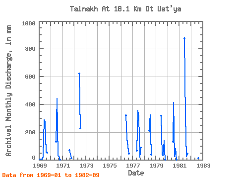
| Year | Jan | Feb | Mar | Apr | May | Jun | Jul | Aug | Sep | Oct | Nov | Dec | Annual | 1969 | 5.19 | 4.28 | 4.14 | 3.80 | 23.14 | 288.38 | 282.52 | 56.08 | 50.21 | 1970 | 132.31 | 456.38 | 30.85 | 26.46 | 1.05 | 1971 | 72.91 | 40.03 | 14.02 | 1972 | 622.22 | 234.85 | 1976 | 320.95 | 159.14 | 97.45 | 44.78 | 1977 | 69.40 | 356.91 | 320.38 | 18.93 | 86.17 | 1978 | 208.31 | 334.40 | 37.16 | 1979 | 318.91 | 38.56 | 31.55 | 137.74 | 2.80 | 1980 | 130.28 | 426.24 | 25.24 | 81.42 | 2.03 | 1981 | 875.31 | 320.38 | 24.54 | 44.78 | 1982 | 492.62 | 143.72 | 12.62 | 19.68 |
|---|
 Return to R-Arctic Net Home Page