|
|
|||||||||||||||||
| Point ID: 6638 | Downloads | Plots | Site Data | Code: 9476 |
|
|
|||||||||||||||||
| Download | |
|---|---|
| Site Descriptor Information | Site Time Series Data |
| Link to all available data | |
| View: | Time Series | All |
| Units: | mm |
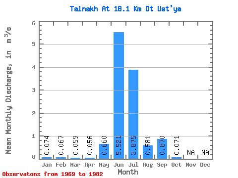
| Statistic | Jan | Feb | Mar | Apr | May | Jun | Jul | Aug | Sep | Oct | Nov | Dec | Annual |
|---|---|---|---|---|---|---|---|---|---|---|---|---|---|
| Mean | 0.07 | 0.07 | 0.06 | 0.06 | 0.66 | 5.52 | 3.88 | 0.58 | 0.87 | 0.07 | |||
| Standard Deviation | 0.47 | 3.42 | 1.85 | 0.38 | 0.54 | 0.09 | |||||||
| Min | 0.07 | 0.07 | 0.06 | 0.06 | 0.33 | 1.92 | 0.55 | 0.18 | 0.29 | 0.01 | |||
| Max | 0.07 | 0.07 | 0.06 | 0.06 | 0.99 | 12.90 | 6.51 | 1.39 | 2.03 | 0.20 | |||
| Coefficient of Variation | 0.71 | 0.62 | 0.48 | 0.66 | 0.62 | 1.22 |
 Return to R-Arctic Net Home Page