|
|
|||||||||||||||||
| Point ID: 5890 | Downloads | Plots | Site Data | Code: 1302 |
|
|
|||||||||||||||||
| Download | |
|---|---|
| Site Descriptor Information | Site Time Series Data |
| Link to all available data | |
| View: | Time Series | All |
| Units: | m3/s |
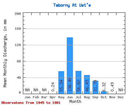
| Statistic | Jan | Feb | Mar | Apr | May | Jun | Jul | Aug | Sep | Oct | Nov | Dec | Annual |
|---|---|---|---|---|---|---|---|---|---|---|---|---|---|
| Mean | 0.24 | 55.22 | 138.43 | 56.55 | 46.58 | 31.86 | 6.40 | 0.57 | |||||
| Standard Deviation | 0.00 | 41.68 | 77.21 | 38.48 | 33.81 | 21.82 | 4.42 | 0.49 | |||||
| Min | 0.24 | 1.01 | 41.57 | 16.42 | 12.63 | 7.58 | 0.76 | 0.24 | |||||
| Max | 0.24 | 186.96 | 330.11 | 224.85 | 171.80 | 112.48 | 20.97 | 1.71 | |||||
| Coefficient of Variation | 0.00 | 0.76 | 0.56 | 0.68 | 0.73 | 0.69 | 0.69 | 0.86 |
 Return to R-Arctic Net Home Page