|
|
|||||||||||||||||
| Point ID: 5890 | Downloads | Plots | Site Data | Code: 1302 |
|
|
|||||||||||||||||
| Download | |
|---|---|
| Site Descriptor Information | Site Time Series Data |
| Link to all available data | |
| View: | Time Series | All |
| Units: | mm |
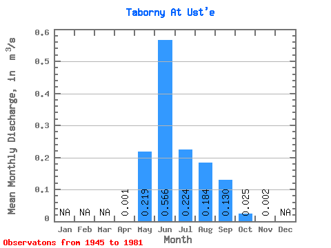
| Statistic | Jan | Feb | Mar | Apr | May | Jun | Jul | Aug | Sep | Oct | Nov | Dec | Annual |
|---|---|---|---|---|---|---|---|---|---|---|---|---|---|
| Mean | 0.00 | 0.22 | 0.57 | 0.22 | 0.18 | 0.13 | 0.03 | 0.00 | |||||
| Standard Deviation | 0.00 | 0.17 | 0.32 | 0.15 | 0.13 | 0.09 | 0.02 | 0.00 | |||||
| Min | 0.00 | 0.00 | 0.17 | 0.07 | 0.05 | 0.03 | 0.00 | 0.00 | |||||
| Max | 0.00 | 0.74 | 1.35 | 0.89 | 0.68 | 0.46 | 0.08 | 0.01 | |||||
| Coefficient of Variation | 0.00 | 0.76 | 0.56 | 0.68 | 0.73 | 0.69 | 0.69 | 0.86 |
 Return to R-Arctic Net Home Page