|
|
|||||||||||||||||
| Point ID: 5857 | Downloads | Plots | Site Data | Other Close Sites | Code: 1005 |
|
|
|||||||||||||||||
| Download | |
|---|---|
| Site Descriptor Information | Site Time Series Data |
| Link to all available data | |
|
|
| View: | Statistics | Time Series |
| Units: | mm |
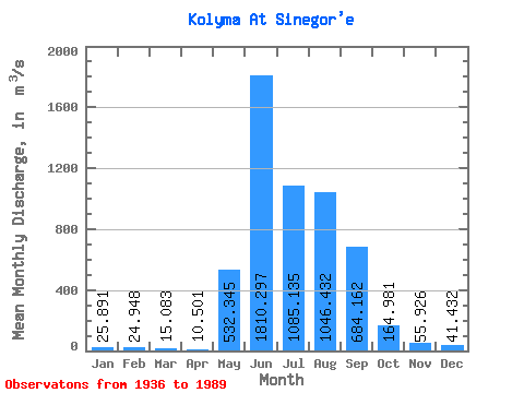
| Statistic | Jan | Feb | Mar | Apr | May | Jun | Jul | Aug | Sep | Oct | Nov | Dec | Annual |
|---|---|---|---|---|---|---|---|---|---|---|---|---|---|
| Mean | 25.89 | 24.95 | 15.08 | 10.50 | 532.35 | 1810.30 | 1085.13 | 1046.43 | 684.16 | 164.98 | 55.93 | 41.43 | 458.51 |
| Standard Deviation | 51.93 | 52.74 | 45.08 | 36.96 | 394.28 | 1024.10 | 464.42 | 490.09 | 390.83 | 97.35 | 44.38 | 60.05 | 123.98 |
| Min | 2.55 | 0.67 | 0.39 | 0.40 | 32.10 | 240.00 | 213.00 | 351.00 | 149.00 | 45.80 | 2.55 | 2.87 | 192.38 |
| Max | 284.00 | 222.00 | 267.00 | 226.00 | 1810.00 | 4160.00 | 2580.00 | 2350.00 | 1780.00 | 513.00 | 225.00 | 274.00 | 695.81 |
| Coefficient of Variation | 2.01 | 2.11 | 2.99 | 3.52 | 0.74 | 0.57 | 0.43 | 0.47 | 0.57 | 0.59 | 0.79 | 1.45 | 0.27 |
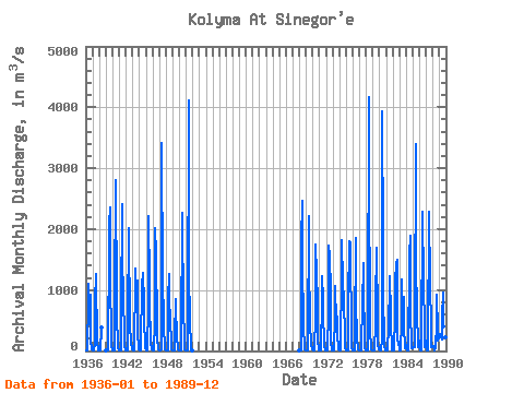
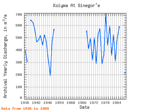
| Year | Jan | Feb | Mar | Apr | May | Jun | Jul | Aug | Sep | Oct | Nov | Dec | Annual | 1936 | 14.00 | 7.27 | 2.46 | 2.84 | 834.00 | 1100.00 | 758.00 | 845.00 | 928.00 | 173.00 | 47.00 | 24.00 | 394.63 | 1937 | 8.43 | 4.54 | 1.72 | 1.61 | 115.00 | 812.00 | 1260.00 | 921.00 | 421.00 | 128.00 | 29.60 | 17.50 | 310.03 | 1938 | 11.80 | 6.37 | 2.02 | 9.78 | 394.00 | 1939 | 6.30 | 3.00 | 1.00 | 1.27 | 684.00 | 1100.00 | 2080.00 | 2350.00 | 1070.00 | 313.00 | 64.10 | 30.60 | 641.94 | 1940 | 16.80 | 8.32 | 2.20 | 3.64 | 827.00 | 2810.00 | 1290.00 | 1800.00 | 529.00 | 132.00 | 49.00 | 26.40 | 624.53 | 1941 | 10.00 | 10.10 | 6.37 | 3.36 | 654.00 | 2410.00 | 1220.00 | 1210.00 | 951.00 | 191.00 | 73.50 | 27.20 | 563.88 | 1942 | 8.37 | 5.40 | 2.50 | 0.80 | 486.00 | 2020.00 | 1250.00 | 1160.00 | 456.00 | 118.00 | 51.00 | 31.80 | 465.82 | 1943 | 17.30 | 10.70 | 7.99 | 11.20 | 1240.00 | 1350.00 | 845.00 | 760.00 | 1150.00 | 276.00 | 66.70 | 24.20 | 479.92 | 1944 | 10.80 | 4.75 | 1.41 | 1.90 | 1180.00 | 1020.00 | 1290.00 | 1040.00 | 1020.00 | 513.00 | 86.00 | 37.20 | 517.09 | 1945 | 4.64 | 1.68 | 1.93 | 4.85 | 758.00 | 2220.00 | 1120.00 | 674.00 | 290.00 | 114.00 | 66.00 | 20.40 | 439.62 | 1946 | 11.50 | 5.16 | 2.13 | 1.21 | 471.00 | 2020.00 | 1580.00 | 927.00 | 986.00 | 204.00 | 42.30 | 19.50 | 522.48 | 1947 | 9.93 | 5.89 | 6.92 | 6.57 | 32.10 | 3410.00 | 1120.00 | 553.00 | 351.00 | 125.00 | 28.20 | 10.10 | 471.56 | 1948 | 2.99 | 1.12 | 0.78 | 2.62 | 837.00 | 1260.00 | 555.00 | 680.00 | 523.00 | 101.00 | 31.10 | 8.18 | 333.57 | 1949 | 2.58 | 0.67 | 0.39 | 1.04 | 201.00 | 847.00 | 528.00 | 415.00 | 232.00 | 56.60 | 19.40 | 4.82 | 192.38 | 1950 | 2.55 | 1.40 | 1.90 | 1.77 | 173.00 | 2260.00 | 848.00 | 1420.00 | 814.00 | 66.90 | 29.50 | 13.90 | 469.41 | 1951 | 5.77 | 3.21 | 2.42 | 2.19 | 269.00 | 4120.00 | 955.00 | 810.00 | 407.00 | 165.00 | 26.10 | 9.70 | 564.62 | 1968 | 4.15 | 2.65 | 1.92 | 2.26 | 1810.00 | 2460.00 | 1060.00 | 813.00 | 317.00 | 131.00 | 27.70 | 6.34 | 553.00 | 1969 | 3.99 | 2.03 | 1.17 | 0.79 | 136.00 | 2220.00 | 1440.00 | 473.00 | 495.00 | 88.50 | 43.10 | 23.70 | 410.61 | 1970 | 11.50 | 5.60 | 3.92 | 3.06 | 600.00 | 1750.00 | 1260.00 | 1430.00 | 634.00 | 170.00 | 36.20 | 15.80 | 493.34 | 1971 | 6.99 | 3.52 | 1.60 | 1.51 | 856.00 | 1230.00 | 842.00 | 477.00 | 275.00 | 86.40 | 27.30 | 11.20 | 318.21 | 1972 | 4.93 | 2.50 | 2.22 | 3.92 | 657.00 | 1730.00 | 852.00 | 1640.00 | 895.00 | 132.00 | 34.00 | 11.40 | 497.08 | 1973 | 4.95 | 2.32 | 1.47 | 1.33 | 587.00 | 1070.00 | 473.00 | 445.00 | 558.00 | 238.00 | 62.70 | 35.30 | 289.92 | 1974 | 18.80 | 11.10 | 7.06 | 8.30 | 1320.00 | 1820.00 | 1100.00 | 871.00 | 913.00 | 179.00 | 53.50 | 16.60 | 526.53 | 1975 | 6.65 | 3.32 | 1.66 | 2.09 | 776.00 | 1810.00 | 1070.00 | 1220.00 | 1780.00 | 144.00 | 44.40 | 20.80 | 573.24 | 1976 | 8.71 | 4.13 | 2.35 | 3.13 | 241.00 | 1860.00 | 673.00 | 351.00 | 211.00 | 45.80 | 28.00 | 9.09 | 286.43 | 1977 | 3.06 | 1.45 | 0.55 | 0.50 | 322.00 | 528.00 | 723.00 | 1440.00 | 1090.00 | 159.00 | 37.00 | 20.00 | 360.38 | 1978 | 9.00 | 4.72 | 3.05 | 2.88 | 352.00 | 4160.00 | 2580.00 | 810.00 | 309.00 | 78.10 | 29.00 | 12.00 | 695.81 | 1979 | 4.21 | 2.24 | 1.34 | 1.57 | 443.00 | 765.00 | 1700.00 | 1610.00 | 578.00 | 95.00 | 37.50 | 19.20 | 438.09 | 1980 | 9.27 | 5.65 | 4.02 | 2.81 | 198.00 | 3940.00 | 1750.00 | 588.00 | 516.00 | 101.00 | 2.55 | 2.87 | 593.35 | 1981 | 2.69 | 17.00 | 62.20 | 0.57 | 419.00 | 722.00 | 753.00 | 1220.00 | 582.00 | 442.00 | 46.20 | 14.70 | 356.78 | 1982 | 6.68 | 3.08 | 1.60 | 0.40 | 583.00 | 1290.00 | 1010.00 | 1440.00 | 1500.00 | 173.00 | 128.00 | 150.00 | 523.81 | 1983 | 13.00 | 5.63 | 4.79 | 1.39 | 497.00 | 1180.00 | 581.00 | 885.00 | 325.00 | 125.00 | 46.00 | 57.50 | 310.11 | 1984 | 95.00 | 105.00 | 6.28 | 3.06 | 495.00 | 916.00 | 1560.00 | 1890.00 | 622.00 | 113.00 | 51.50 | 46.40 | 491.94 | 1985 | 40.60 | 65.20 | 71.30 | 54.70 | 438.00 | 3400.00 | 1220.00 | 855.00 | 623.00 | 121.00 | 65.70 | 105.00 | 588.29 | 1986 | 112.00 | 169.00 | 15.70 | 6.30 | 52.00 | 2290.00 | 813.00 | 1690.00 | 1240.00 | 250.00 | 65.20 | 66.80 | 564.17 | 1987 | 112.00 | 169.00 | 15.70 | 6.30 | 52.00 | 2290.00 | 813.00 | 1690.00 | 1240.00 | 250.00 | 65.20 | 66.80 | 564.17 | 1988 | 77.90 | 61.30 | 52.10 | 9.50 | 58.00 | 240.00 | 213.00 | 917.00 | 334.00 | 167.00 | 204.00 | 242.00 | 214.65 | 1989 | 284.00 | 222.00 | 267.00 | 226.00 | 182.00 | 551.00 | 965.00 | 398.00 | 149.00 | 139.00 | 225.00 | 274.00 | 323.50 |
|---|
| Other Close Sites | ||||||
|---|---|---|---|---|---|---|
| PointID | Latitude | Longitude | Drainage Area | Source | Name | |
| 5878 | "Bokhalcha At 5.4 km from ust'ya" | 62.10 | 2678112 | SHI | 5.40 | |
 Return to R-Arctic Net Home Page