|
|
|||||||||||||||||
| Point ID: 5839 | Downloads | Plots | Site Data | Other Close Sites | Code: 10AA001 |
|
|
|||||||||||||||||
| Download | |
|---|---|
| Site Descriptor Information | Site Time Series Data |
| Link to all available data | |
|
|
| View: | Statistics | Time Series |
| Units: | mm |
| Statistic | Jan | Feb | Mar | Apr | May | Jun | Jul | Aug | Sep | Oct | Nov | Dec | Annual |
|---|---|---|---|---|---|---|---|---|---|---|---|---|---|
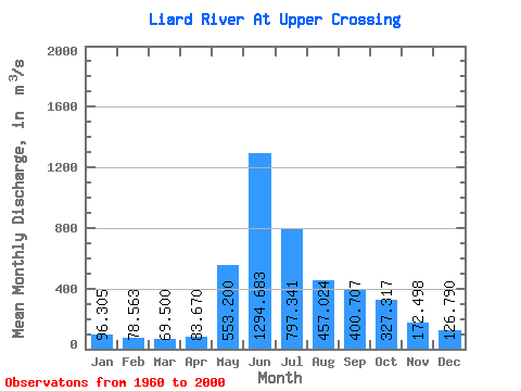
| Mean | 96.31 | 78.56 | 69.50 | 83.67 | 553.20 | 1294.68 | 797.34 | 457.02 | 400.71 | 327.32 | 172.50 | 126.79 | 371.53 |
| Standard Deviation | 19.07 | 15.92 | 12.06 | 20.11 | 156.08 | 362.59 | 243.54 | 116.27 | 114.02 | 89.01 | 45.82 | 29.33 | 60.26 |
| Min | 62.90 | 54.00 | 50.50 | 54.30 | 235.00 | 699.00 | 369.00 | 226.00 | 199.00 | 201.00 | 99.40 | 73.70 | 266.91 |
| Max | 153.00 | 127.00 | 99.10 | 151.00 | 921.00 | 2240.00 | 1340.00 | 723.00 | 741.00 | 561.00 | 290.00 | 207.00 | 517.33 |
| Coefficient of Variation | 0.20 | 0.20 | 0.17 | 0.24 | 0.28 | 0.28 | 0.30 | 0.25 | 0.28 | 0.27 | 0.27 | 0.23 | 0.16 |
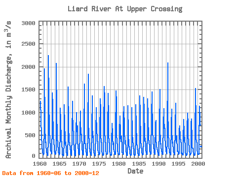
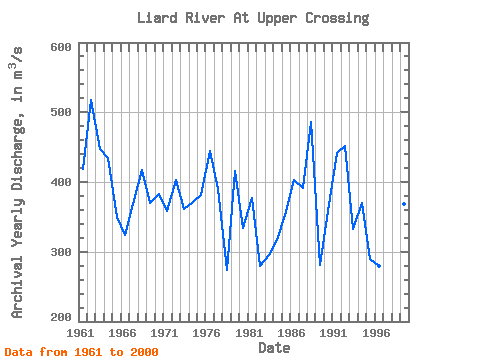
| Year | Jan | Feb | Mar | Apr | May | Jun | Jul | Aug | Sep | Oct | Nov | Dec | Annual | 1960 | 1240.00 | 857.00 | 480.00 | 455.00 | 280.00 | 119.00 | 113.00 | 1961 | 99.10 | 79.30 | 75.00 | 88.80 | 740.00 | 1950.00 | 710.00 | 344.00 | 404.00 | 300.00 | 121.00 | 119.00 | 419.18 | 1962 | 99.10 | 79.30 | 56.10 | 59.50 | 413.00 | 2240.00 | 1260.00 | 633.00 | 550.00 | 429.00 | 219.00 | 170.00 | 517.33 | 1963 | 142.00 | 127.00 | 99.10 | 95.50 | 747.00 | 1420.00 | 1150.00 | 438.00 | 435.00 | 378.00 | 197.00 | 135.00 | 446.97 | 1964 | 108.00 | 85.00 | 85.00 | 90.60 | 235.00 | 2070.00 | 898.00 | 589.00 | 451.00 | 302.00 | 168.00 | 127.00 | 434.05 | 1965 | 102.00 | 85.00 | 70.80 | 96.10 | 590.00 | 1090.00 | 808.00 | 411.00 | 395.00 | 341.00 | 138.00 | 73.70 | 350.05 | 1966 | 69.30 | 55.90 | 50.50 | 64.40 | 369.00 | 1170.00 | 717.00 | 441.00 | 304.00 | 348.00 | 177.00 | 130.00 | 324.68 | 1967 | 98.50 | 77.40 | 63.50 | 61.40 | 517.00 | 1550.00 | 693.00 | 377.00 | 301.00 | 333.00 | 197.00 | 154.00 | 368.57 | 1968 | 103.00 | 71.40 | 60.30 | 62.60 | 498.00 | 1240.00 | 1060.00 | 596.00 | 588.00 | 377.00 | 203.00 | 145.00 | 417.02 | 1969 | 82.20 | 57.40 | 51.80 | 82.00 | 546.00 | 990.00 | 570.00 | 587.00 | 706.00 | 363.00 | 235.00 | 165.00 | 369.62 | 1970 | 111.00 | 85.40 | 75.00 | 75.70 | 554.00 | 1030.00 | 803.00 | 528.00 | 479.00 | 521.00 | 214.00 | 126.00 | 383.51 | 1971 | 91.60 | 80.30 | 69.50 | 90.80 | 531.00 | 1620.00 | 671.00 | 318.00 | 315.00 | 253.00 | 148.00 | 113.00 | 358.43 | 1972 | 81.70 | 59.40 | 54.40 | 62.50 | 589.00 | 1830.00 | 800.00 | 508.00 | 338.00 | 257.00 | 142.00 | 111.00 | 402.75 | 1973 | 93.90 | 77.40 | 64.50 | 87.10 | 564.00 | 1360.00 | 737.00 | 451.00 | 476.00 | 220.00 | 120.00 | 86.20 | 361.43 | 1974 | 68.90 | 61.00 | 53.70 | 54.30 | 549.00 | 1100.00 | 866.00 | 668.00 | 384.00 | 344.00 | 182.00 | 133.00 | 371.99 | 1975 | 96.00 | 82.90 | 73.90 | 88.50 | 486.00 | 1300.00 | 1040.00 | 474.00 | 384.00 | 304.00 | 144.00 | 111.00 | 382.02 | 1976 | 77.90 | 66.60 | 64.50 | 87.00 | 668.00 | 1560.00 | 1290.00 | 577.00 | 393.00 | 281.00 | 169.00 | 107.00 | 445.08 | 1977 | 95.40 | 92.90 | 82.00 | 104.00 | 602.00 | 1410.00 | 883.00 | 487.00 | 361.00 | 303.00 | 150.00 | 104.00 | 389.52 | 1978 | 74.60 | 65.00 | 58.10 | 67.70 | 327.00 | 756.00 | 525.00 | 420.00 | 301.00 | 329.00 | 201.00 | 169.00 | 274.45 | 1979 | 108.00 | 76.00 | 75.80 | 76.20 | 518.00 | 1470.00 | 1220.00 | 541.00 | 334.00 | 288.00 | 176.00 | 107.00 | 415.83 | 1980 | 94.00 | 90.00 | 73.10 | 81.20 | 564.00 | 923.00 | 535.00 | 466.00 | 358.00 | 483.00 | 224.00 | 120.00 | 334.27 | 1981 | 116.00 | 103.00 | 88.40 | 81.70 | 903.00 | 1120.00 | 627.00 | 320.00 | 435.00 | 338.00 | 233.00 | 159.00 | 377.01 | 1982 | 99.10 | 62.90 | 57.60 | 62.20 | 393.00 | 1150.00 | 522.00 | 280.00 | 274.00 | 231.00 | 124.00 | 91.40 | 278.93 | 1983 | 70.20 | 54.00 | 58.30 | 64.80 | 428.00 | 1100.00 | 529.00 | 361.00 | 389.00 | 259.00 | 138.00 | 87.10 | 294.87 | 1984 | 62.90 | 56.90 | 58.90 | 74.50 | 469.00 | 1170.00 | 687.00 | 391.00 | 362.00 | 225.00 | 138.00 | 99.30 | 316.21 | 1985 | 78.40 | 64.50 | 57.10 | 62.80 | 376.00 | 1360.00 | 950.00 | 440.00 | 362.00 | 271.00 | 145.00 | 109.00 | 356.32 | 1986 | 89.30 | 68.40 | 67.60 | 81.20 | 412.00 | 1330.00 | 1040.00 | 478.00 | 374.00 | 433.00 | 290.00 | 177.00 | 403.38 | 1987 | 115.00 | 86.60 | 77.90 | 84.00 | 562.00 | 1300.00 | 887.00 | 441.00 | 394.00 | 377.00 | 208.00 | 157.00 | 390.79 | 1988 | 113.00 | 86.40 | 78.60 | 91.50 | 921.00 | 1450.00 | 1340.00 | 581.00 | 392.00 | 372.00 | 235.00 | 169.00 | 485.79 | 1989 | 115.00 | 90.90 | 77.40 | 142.00 | 753.00 | 820.00 | 423.00 | 263.00 | 199.00 | 226.00 | 138.00 | 117.00 | 280.36 | 1990 | 89.80 | 71.30 | 63.30 | 83.20 | 642.00 | 1500.00 | 704.00 | 309.00 | 321.00 | 257.00 | 152.00 | 115.00 | 358.97 | 1991 | 94.00 | 89.60 | 83.60 | 151.00 | 715.00 | 1080.00 | 826.00 | 647.00 | 646.00 | 489.00 | 267.00 | 207.00 | 441.27 | 1992 | 153.00 | 116.00 | 91.90 | 90.10 | 403.00 | 2080.00 | 1060.00 | 520.00 | 364.00 | 283.00 | 124.00 | 127.00 | 451.00 | 1993 | 100.00 | 83.50 | 74.80 | 88.60 | 709.00 | 1070.00 | 632.00 | 350.00 | 288.00 | 351.00 | 145.00 | 108.00 | 333.32 | 1994 | 118.00 | 90.50 | 74.20 | 93.90 | 684.00 | 1200.00 | 642.00 | 347.00 | 397.00 | 481.00 | 150.00 | 153.00 | 369.22 | 1995 | 118.00 | 97.30 | 82.20 | 108.00 | 605.00 | 699.00 | 446.00 | 419.00 | 405.00 | 280.00 | 99.40 | 110.00 | 289.07 | 1996 | 98.90 | 82.00 | 69.60 | 69.00 | 387.00 | 846.00 | 555.00 | 376.00 | 458.00 | 201.00 | 111.00 | 102.00 | 279.62 | 1997 | 75.90 | 64.20 | 54.30 | 81.40 | 652.00 | 988.00 | 729.00 | 502.00 | 330.00 | 225.00 | 160.00 | 114.00 | 331.32 | 1998 | 87.80 | 73.40 | 69.00 | 111.00 | 744.00 | 850.00 | 369.00 | 226.00 | 215.00 | 214.00 | 146.00 | 97.70 | 266.91 | 1999 | 76.80 | 64.90 | 56.30 | 68.70 | 458.00 | 1520.00 | 765.00 | 430.00 | 371.00 | 312.00 | 176.00 | 115.00 | 367.81 | 2000 | 84.90 | 81.60 | 82.40 | 81.30 | 305.00 | 1130.00 | 865.00 | 723.00 | 741.00 | 561.00 | 249.00 | 165.00 | 422.43 |
|---|
| Other Close Sites | ||||||
|---|---|---|---|---|---|---|
| PointID | Latitude | Longitude | Drainage Area | Source | Name | |
| 2755 | "DEASE RIVER NEAR THE MOUTH" | 59.85 | 2067147 | Hydat | ||
 Return to R-Arctic Net Home Page