|
|
|||||||||||||||||
| Point ID: 5839 | Downloads | Plots | Site Data | Other Close Sites | Code: 10AA001 |
|
|
|||||||||||||||||
| Download | |
|---|---|
| Site Descriptor Information | Site Time Series Data |
| Link to all available data | |
| View: | Time Series | All |
| Units: | mm |
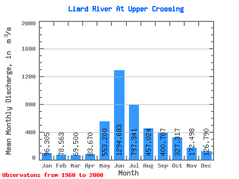
| Statistic | Jan | Feb | Mar | Apr | May | Jun | Jul | Aug | Sep | Oct | Nov | Dec | Annual |
|---|---|---|---|---|---|---|---|---|---|---|---|---|---|
| Mean | 96.31 | 78.56 | 69.50 | 83.67 | 553.20 | 1294.68 | 797.34 | 457.02 | 400.71 | 327.32 | 172.50 | 126.79 | 371.53 |
| Standard Deviation | 19.07 | 15.92 | 12.06 | 20.11 | 156.08 | 362.59 | 243.54 | 116.27 | 114.02 | 89.01 | 45.82 | 29.33 | 60.26 |
| Min | 62.90 | 54.00 | 50.50 | 54.30 | 235.00 | 699.00 | 369.00 | 226.00 | 199.00 | 201.00 | 99.40 | 73.70 | 266.91 |
| Max | 153.00 | 127.00 | 99.10 | 151.00 | 921.00 | 2240.00 | 1340.00 | 723.00 | 741.00 | 561.00 | 290.00 | 207.00 | 517.33 |
| Coefficient of Variation | 0.20 | 0.20 | 0.17 | 0.24 | 0.28 | 0.28 | 0.30 | 0.25 | 0.28 | 0.27 | 0.27 | 0.23 | 0.16 |
| Other Close Sites | ||||||
|---|---|---|---|---|---|---|
| PointID | Latitude | Longitude | Drainage Area | Source | Name | |
| 2755 | "DEASE RIVER NEAR THE MOUTH" | 59.85 | 2067147 | Hydat | ||
 Return to R-Arctic Net Home Page