|
|
|||||||||||||||||
| Point ID: 5839 | Downloads | Plots | Site Data | Other Close Sites | Code: 10AA001 |
|
|
|||||||||||||||||
| Download | |
|---|---|
| Site Descriptor Information | Site Time Series Data |
| Link to all available data | |
|
|
| View: | Statistics | Time Series |
| Units: | m3/s |
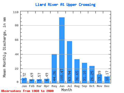
| Statistic | Jan | Feb | Mar | Apr | May | Jun | Jul | Aug | Sep | Oct | Nov | Dec | Annual |
|---|---|---|---|---|---|---|---|---|---|---|---|---|---|
| Mean | 7.72 | 5.74 | 5.57 | 6.49 | 44.35 | 100.47 | 63.93 | 36.64 | 31.10 | 26.24 | 13.39 | 10.17 | 351.07 |
| Standard Deviation | 1.53 | 1.16 | 0.97 | 1.56 | 12.52 | 28.14 | 19.53 | 9.32 | 8.85 | 7.14 | 3.56 | 2.35 | 56.94 |
| Min | 5.04 | 3.94 | 4.05 | 4.21 | 18.84 | 54.25 | 29.59 | 18.12 | 15.44 | 16.12 | 7.71 | 5.91 | 252.20 |
| Max | 12.27 | 9.28 | 7.95 | 11.72 | 73.84 | 173.84 | 107.44 | 57.97 | 57.51 | 44.98 | 22.50 | 16.60 | 488.83 |
| Coefficient of Variation | 0.20 | 0.20 | 0.17 | 0.24 | 0.28 | 0.28 | 0.30 | 0.25 | 0.28 | 0.27 | 0.27 | 0.23 | 0.16 |
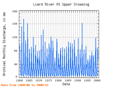
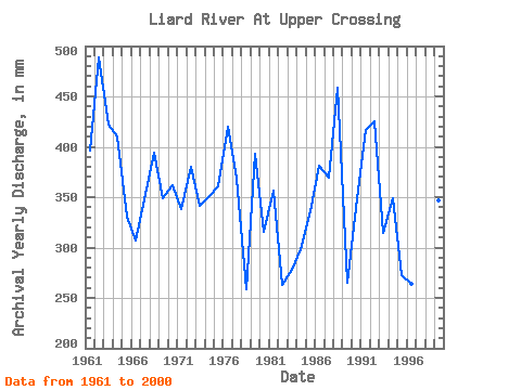
| Year | Jan | Feb | Mar | Apr | May | Jun | Jul | Aug | Sep | Oct | Nov | Dec | Annual | 1960 | 96.23 | 68.71 | 38.49 | 35.31 | 22.45 | 9.23 | 9.06 | 1961 | 7.95 | 5.79 | 6.01 | 6.89 | 59.33 | 151.33 | 56.93 | 27.58 | 31.35 | 24.05 | 9.39 | 9.54 | 396.09 | 1962 | 7.95 | 5.79 | 4.50 | 4.62 | 33.11 | 173.84 | 101.03 | 50.75 | 42.68 | 34.40 | 17.00 | 13.63 | 488.83 | 1963 | 11.39 | 9.28 | 7.95 | 7.41 | 59.89 | 110.20 | 92.21 | 35.12 | 33.76 | 30.31 | 15.29 | 10.82 | 422.34 | 1964 | 8.66 | 6.21 | 6.81 | 7.03 | 18.84 | 160.64 | 72.00 | 47.23 | 35.00 | 24.21 | 13.04 | 10.18 | 410.14 | 1965 | 8.18 | 6.21 | 5.68 | 7.46 | 47.31 | 84.59 | 64.78 | 32.95 | 30.65 | 27.34 | 10.71 | 5.91 | 330.77 | 1966 | 5.56 | 4.08 | 4.05 | 5.00 | 29.59 | 90.80 | 57.49 | 35.36 | 23.59 | 27.90 | 13.74 | 10.42 | 306.79 | 1967 | 7.90 | 5.65 | 5.09 | 4.76 | 41.45 | 120.29 | 55.56 | 30.23 | 23.36 | 26.70 | 15.29 | 12.35 | 348.26 | 1968 | 8.26 | 5.22 | 4.83 | 4.86 | 39.93 | 96.23 | 84.99 | 47.79 | 45.63 | 30.23 | 15.75 | 11.63 | 394.05 | 1969 | 6.59 | 4.19 | 4.15 | 6.36 | 43.78 | 76.83 | 45.70 | 47.06 | 54.79 | 29.11 | 18.24 | 13.23 | 349.25 | 1970 | 8.90 | 6.24 | 6.01 | 5.88 | 44.42 | 79.93 | 64.38 | 42.34 | 37.17 | 41.77 | 16.61 | 10.10 | 362.38 | 1971 | 7.34 | 5.87 | 5.57 | 7.05 | 42.58 | 125.72 | 53.80 | 25.50 | 24.45 | 20.29 | 11.49 | 9.06 | 338.69 | 1972 | 6.55 | 4.34 | 4.36 | 4.85 | 47.23 | 142.02 | 64.14 | 40.73 | 26.23 | 20.61 | 11.02 | 8.90 | 380.56 | 1973 | 7.53 | 5.65 | 5.17 | 6.76 | 45.22 | 105.54 | 59.09 | 36.16 | 36.94 | 17.64 | 9.31 | 6.91 | 341.51 | 1974 | 5.52 | 4.46 | 4.31 | 4.21 | 44.02 | 85.36 | 69.44 | 53.56 | 29.80 | 27.58 | 14.12 | 10.66 | 351.50 | 1975 | 7.70 | 6.06 | 5.92 | 6.87 | 38.97 | 100.89 | 83.39 | 38.01 | 29.80 | 24.38 | 11.18 | 8.90 | 360.98 | 1976 | 6.25 | 4.87 | 5.17 | 6.75 | 53.56 | 121.06 | 103.43 | 46.26 | 30.50 | 22.53 | 13.12 | 8.58 | 420.56 | 1977 | 7.65 | 6.79 | 6.58 | 8.07 | 48.27 | 109.42 | 70.80 | 39.05 | 28.02 | 24.29 | 11.64 | 8.34 | 368.07 | 1978 | 5.98 | 4.75 | 4.66 | 5.25 | 26.22 | 58.67 | 42.09 | 33.67 | 23.36 | 26.38 | 15.60 | 13.55 | 259.33 | 1979 | 8.66 | 5.55 | 6.08 | 5.91 | 41.53 | 114.08 | 97.82 | 43.38 | 25.92 | 23.09 | 13.66 | 8.58 | 392.93 | 1980 | 7.54 | 6.58 | 5.86 | 6.30 | 45.22 | 71.63 | 42.90 | 37.36 | 27.78 | 38.73 | 17.38 | 9.62 | 315.86 | 1981 | 9.30 | 7.53 | 7.09 | 6.34 | 72.40 | 86.92 | 50.27 | 25.66 | 33.76 | 27.10 | 18.08 | 12.75 | 356.24 | 1982 | 7.95 | 4.59 | 4.62 | 4.83 | 31.51 | 89.25 | 41.85 | 22.45 | 21.26 | 18.52 | 9.62 | 7.33 | 263.57 | 1983 | 5.63 | 3.94 | 4.67 | 5.03 | 34.32 | 85.36 | 42.41 | 28.95 | 30.19 | 20.77 | 10.71 | 6.98 | 278.62 | 1984 | 5.04 | 4.16 | 4.72 | 5.78 | 37.60 | 90.80 | 55.08 | 31.35 | 28.09 | 18.04 | 10.71 | 7.96 | 298.79 | 1985 | 6.29 | 4.71 | 4.58 | 4.87 | 30.15 | 105.54 | 76.17 | 35.28 | 28.09 | 21.73 | 11.25 | 8.74 | 336.69 | 1986 | 7.16 | 5.00 | 5.42 | 6.30 | 33.03 | 103.21 | 83.39 | 38.33 | 29.02 | 34.72 | 22.50 | 14.19 | 381.15 | 1987 | 9.22 | 6.33 | 6.25 | 6.52 | 45.06 | 100.89 | 71.12 | 35.36 | 30.58 | 30.23 | 16.14 | 12.59 | 369.26 | 1988 | 9.06 | 6.31 | 6.30 | 7.10 | 73.84 | 112.53 | 107.44 | 46.58 | 30.42 | 29.83 | 18.24 | 13.55 | 459.03 | 1989 | 9.22 | 6.64 | 6.21 | 11.02 | 60.38 | 63.64 | 33.92 | 21.09 | 15.44 | 18.12 | 10.71 | 9.38 | 264.91 | 1990 | 7.20 | 5.21 | 5.08 | 6.46 | 51.48 | 116.41 | 56.45 | 24.78 | 24.91 | 20.61 | 11.80 | 9.22 | 339.19 | 1991 | 7.54 | 6.55 | 6.70 | 11.72 | 57.33 | 83.81 | 66.23 | 51.88 | 50.13 | 39.21 | 20.72 | 16.60 | 416.96 | 1992 | 12.27 | 8.47 | 7.37 | 6.99 | 32.31 | 161.42 | 84.99 | 41.69 | 28.25 | 22.69 | 9.62 | 10.18 | 426.15 | 1993 | 8.02 | 6.10 | 6.00 | 6.88 | 56.85 | 83.04 | 50.67 | 28.06 | 22.35 | 28.14 | 11.25 | 8.66 | 314.96 | 1994 | 9.46 | 6.61 | 5.95 | 7.29 | 54.84 | 93.13 | 51.48 | 27.82 | 30.81 | 38.57 | 11.64 | 12.27 | 348.88 | 1995 | 9.46 | 7.11 | 6.59 | 8.38 | 48.51 | 54.25 | 35.76 | 33.59 | 31.43 | 22.45 | 7.71 | 8.82 | 273.15 | 1996 | 7.93 | 5.99 | 5.58 | 5.36 | 31.03 | 65.65 | 44.50 | 30.15 | 35.54 | 16.12 | 8.61 | 8.18 | 264.22 | 1997 | 6.09 | 4.69 | 4.35 | 6.32 | 52.28 | 76.67 | 58.45 | 40.25 | 25.61 | 18.04 | 12.42 | 9.14 | 313.06 | 1998 | 7.04 | 5.36 | 5.53 | 8.61 | 59.65 | 65.96 | 29.59 | 18.12 | 16.68 | 17.16 | 11.33 | 7.83 | 252.20 | 1999 | 6.16 | 4.74 | 4.51 | 5.33 | 36.72 | 117.96 | 61.34 | 34.48 | 28.79 | 25.02 | 13.66 | 9.22 | 347.55 | 2000 | 6.81 | 5.96 | 6.61 | 6.31 | 24.45 | 87.69 | 69.36 | 57.97 | 57.51 | 44.98 | 19.32 | 13.23 | 399.16 |
|---|
| Other Close Sites | ||||||
|---|---|---|---|---|---|---|
| PointID | Latitude | Longitude | Drainage Area | Source | Name | |
| 2755 | "DEASE RIVER NEAR THE MOUTH" | 59.85 | 2067147 | Hydat | ||
 Return to R-Arctic Net Home Page