|
|
|||||||||||||||||
| Point ID: 6929 | Downloads | Plots | Site Data | Other Close Sites | Code: 10594 |
|
|
|||||||||||||||||
| Download | |
|---|---|
| Site Descriptor Information | Site Time Series Data |
| Link to all available data | |
| View: | Time Series | All |
| Units: | mm |
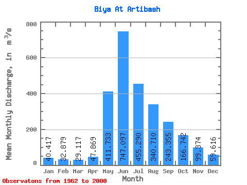
| Statistic | Jan | Feb | Mar | Apr | May | Jun | Jul | Aug | Sep | Oct | Nov | Dec | Annual |
|---|---|---|---|---|---|---|---|---|---|---|---|---|---|
| Mean | 40.42 | 32.88 | 29.12 | 47.87 | 411.73 | 747.10 | 455.29 | 340.71 | 243.35 | 166.74 | 99.37 | 59.62 | 226.75 |
| Standard Deviation | 6.17 | 4.43 | 4.63 | 15.11 | 140.56 | 308.49 | 153.14 | 154.30 | 65.95 | 37.62 | 20.71 | 12.19 | 44.95 |
| Min | 27.40 | 20.30 | 17.00 | 25.70 | 148.00 | 431.00 | 222.00 | 157.00 | 142.00 | 111.00 | 69.00 | 41.60 | 155.12 |
| Max | 56.80 | 44.00 | 39.10 | 84.40 | 735.00 | 1700.00 | 918.00 | 824.00 | 402.00 | 292.00 | 157.00 | 102.00 | 329.47 |
| Coefficient of Variation | 0.15 | 0.14 | 0.16 | 0.32 | 0.34 | 0.41 | 0.34 | 0.45 | 0.27 | 0.23 | 0.21 | 0.20 | 0.20 |
| Other Close Sites | ||||||
|---|---|---|---|---|---|---|
| PointID | Latitude | Longitude | Drainage Area | Source | Name | |
| 6668 | "Biya At Kebezen'" | 51.90 | -210419 | SHI | 271.00 | |
 Return to R-Arctic Net Home Page