|
|
|||||||||||||||||
| Point ID: 6668 | Downloads | Plots | Site Data | Other Close Sites | Code: 10042 |
|
|
|||||||||||||||||
| Download | |
|---|---|
| Site Descriptor Information | Site Time Series Data |
| Link to all available data | |
| View: | Time Series | All |
| Units: | mm |
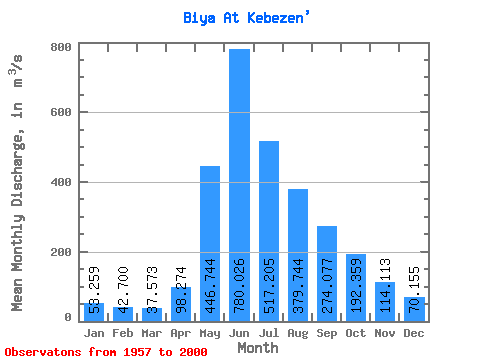
| Statistic | Jan | Feb | Mar | Apr | May | Jun | Jul | Aug | Sep | Oct | Nov | Dec | Annual |
|---|---|---|---|---|---|---|---|---|---|---|---|---|---|
| Mean | 53.26 | 42.70 | 37.57 | 98.27 | 446.74 | 780.03 | 517.21 | 379.74 | 274.08 | 192.36 | 114.11 | 70.16 | 246.86 |
| Standard Deviation | 10.48 | 10.22 | 9.92 | 124.23 | 134.78 | 289.36 | 194.96 | 164.79 | 81.42 | 52.63 | 19.85 | 13.64 | 47.62 |
| Min | 29.20 | 20.30 | 21.20 | 12.20 | 221.00 | 467.00 | 248.00 | 156.00 | 147.00 | 114.00 | 80.60 | 22.80 | 167.46 |
| Max | 76.20 | 60.30 | 79.60 | 828.00 | 841.00 | 1670.00 | 1300.00 | 890.00 | 460.00 | 359.00 | 163.00 | 102.00 | 373.94 |
| Coefficient of Variation | 0.20 | 0.24 | 0.26 | 1.26 | 0.30 | 0.37 | 0.38 | 0.43 | 0.30 | 0.27 | 0.17 | 0.19 | 0.19 |
| Other Close Sites | ||||||
|---|---|---|---|---|---|---|
| PointID | Latitude | Longitude | Drainage Area | Source | Name | |
| 6929 | "Biya At Artibash" | 51.80 | -200048 | SHI | 299.00 | |
 Return to R-Arctic Net Home Page