|
|
|||||||||||||||||
| Point ID: 6929 | Downloads | Plots | Site Data | Other Close Sites | Code: 10594 |
|
|
|||||||||||||||||
| Download | |
|---|---|
| Site Descriptor Information | Site Time Series Data |
| Link to all available data | |
|
|
| View: | Statistics | Time Series |
| Units: | mm |
| Statistic | Jan | Feb | Mar | Apr | May | Jun | Jul | Aug | Sep | Oct | Nov | Dec | Annual |
|---|---|---|---|---|---|---|---|---|---|---|---|---|---|
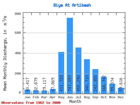
| Mean | 40.42 | 32.88 | 29.12 | 47.87 | 411.73 | 747.10 | 455.29 | 340.71 | 243.35 | 166.74 | 99.37 | 59.62 | 226.75 |
| Standard Deviation | 6.17 | 4.43 | 4.63 | 15.11 | 140.56 | 308.49 | 153.14 | 154.30 | 65.95 | 37.62 | 20.71 | 12.19 | 44.95 |
| Min | 27.40 | 20.30 | 17.00 | 25.70 | 148.00 | 431.00 | 222.00 | 157.00 | 142.00 | 111.00 | 69.00 | 41.60 | 155.12 |
| Max | 56.80 | 44.00 | 39.10 | 84.40 | 735.00 | 1700.00 | 918.00 | 824.00 | 402.00 | 292.00 | 157.00 | 102.00 | 329.47 |
| Coefficient of Variation | 0.15 | 0.14 | 0.16 | 0.32 | 0.34 | 0.41 | 0.34 | 0.45 | 0.27 | 0.23 | 0.21 | 0.20 | 0.20 |
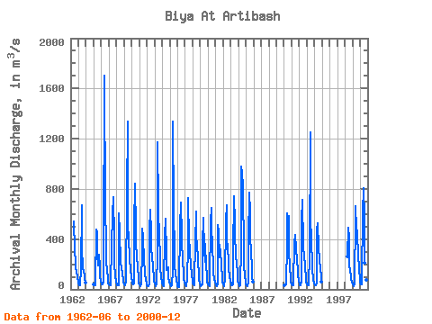
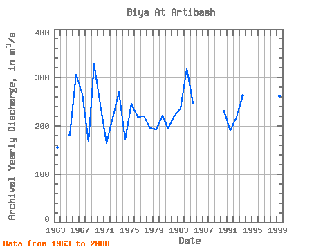
| Year | Jan | Feb | Mar | Apr | May | Jun | Jul | Aug | Sep | Oct | Nov | Dec | Annual | 1962 | 544.00 | 312.00 | 213.00 | 162.00 | 144.00 | 93.80 | 57.30 | 1963 | 44.10 | 35.50 | 32.30 | 31.40 | 159.00 | 667.00 | 336.00 | 169.00 | 143.00 | 111.00 | 81.50 | 51.70 | 155.12 | 1965 | 41.50 | 32.20 | 29.00 | 34.30 | 479.00 | 458.00 | 275.00 | 193.00 | 273.00 | 185.00 | 107.00 | 70.00 | 181.42 | 1966 | 46.40 | 39.90 | 38.70 | 51.20 | 269.00 | 1700.00 | 648.00 | 366.00 | 217.00 | 154.00 | 85.70 | 48.90 | 305.40 | 1967 | 38.50 | 33.20 | 31.30 | 37.80 | 337.00 | 605.00 | 602.00 | 736.00 | 402.00 | 204.00 | 109.00 | 61.90 | 266.48 | 1968 | 36.70 | 34.20 | 30.00 | 33.70 | 605.00 | 449.00 | 222.00 | 171.00 | 173.00 | 126.00 | 69.00 | 59.10 | 167.39 | 1969 | 39.90 | 34.10 | 28.90 | 58.70 | 735.00 | 1340.00 | 566.00 | 357.00 | 299.00 | 237.00 | 156.00 | 102.00 | 329.47 | 1970 | 53.80 | 44.00 | 39.10 | 48.00 | 503.00 | 839.00 | 473.00 | 349.00 | 274.00 | 170.00 | 100.00 | 48.40 | 245.11 | 1971 | 38.80 | 30.90 | 24.30 | 39.60 | 314.00 | 486.00 | 411.00 | 226.00 | 149.00 | 123.00 | 76.40 | 44.10 | 163.59 | 1972 | 28.90 | 24.80 | 24.10 | 40.10 | 462.00 | 634.00 | 449.00 | 307.00 | 273.00 | 170.00 | 103.00 | 68.00 | 215.32 | 1973 | 43.10 | 32.40 | 27.60 | 46.30 | 265.00 | 1170.00 | 653.00 | 390.00 | 294.00 | 175.00 | 95.30 | 58.80 | 270.88 | 1974 | 43.10 | 31.60 | 28.10 | 51.50 | 420.00 | 566.00 | 285.00 | 157.00 | 154.00 | 178.00 | 96.70 | 50.40 | 171.78 | 1975 | 36.50 | 30.00 | 23.20 | 29.00 | 148.00 | 1340.00 | 631.00 | 289.00 | 181.00 | 124.00 | 75.50 | 41.60 | 245.73 | 1976 | 27.40 | 20.30 | 17.00 | 25.70 | 501.00 | 690.00 | 424.00 | 412.00 | 205.00 | 155.00 | 86.30 | 52.80 | 218.04 | 1977 | 38.50 | 32.80 | 28.40 | 84.30 | 351.00 | 725.00 | 381.00 | 329.00 | 293.00 | 199.00 | 110.00 | 66.60 | 219.88 | 1978 | 45.70 | 37.60 | 30.70 | 73.20 | 363.00 | 619.00 | 334.00 | 380.00 | 221.00 | 129.00 | 74.30 | 45.10 | 196.05 | 1979 | 30.40 | 27.90 | 29.70 | 39.10 | 364.00 | 569.00 | 312.00 | 221.00 | 361.00 | 174.00 | 117.00 | 62.70 | 192.32 | 1980 | 40.00 | 32.00 | 27.20 | 38.00 | 540.00 | 650.00 | 525.00 | 310.00 | 220.00 | 131.00 | 82.60 | 54.00 | 220.82 | 1981 | 38.10 | 29.30 | 27.00 | 48.80 | 516.00 | 460.00 | 258.00 | 297.00 | 319.00 | 182.00 | 99.00 | 57.80 | 194.33 | 1982 | 40.80 | 32.90 | 28.00 | 84.40 | 548.00 | 672.00 | 362.00 | 359.00 | 194.00 | 153.00 | 112.00 | 62.20 | 220.69 | 1983 | 44.70 | 32.60 | 31.70 | 40.00 | 292.00 | 742.00 | 532.00 | 458.00 | 255.00 | 214.00 | 124.00 | 71.10 | 236.43 | 1984 | 43.40 | 31.50 | 24.90 | 32.70 | 336.00 | 975.00 | 918.00 | 824.00 | 286.00 | 187.00 | 107.00 | 60.90 | 318.87 | 1985 | 39.20 | 34.20 | 24.70 | 53.30 | 391.00 | 769.00 | 614.00 | 421.00 | 300.00 | 168.00 | 94.40 | 62.10 | 247.57 | 1990 | 34.70 | 30.00 | 29.50 | 39.40 | 357.00 | 608.00 | 442.00 | 581.00 | 322.00 | 170.00 | 96.70 | 58.10 | 230.70 | 1991 | 40.30 | 32.00 | 29.50 | 42.10 | 372.00 | 431.00 | 423.00 | 335.00 | 228.00 | 163.00 | 116.00 | 67.00 | 189.91 | 1992 | 42.20 | 34.60 | 29.30 | 61.60 | 539.00 | 715.00 | 340.00 | 253.00 | 282.00 | 178.00 | 95.80 | 60.10 | 219.22 | 1993 | 40.40 | 34.40 | 33.00 | 56.20 | 257.00 | 1250.00 | 611.00 | 349.00 | 234.00 | 164.00 | 84.20 | 49.40 | 263.55 | 1994 | 36.90 | 35.60 | 33.30 | 53.60 | 466.00 | 524.00 | 324.00 | 240.00 | 249.00 | 154.00 | 110.00 | 62.90 | 190.78 | 1998 | 261.00 | 488.00 | 409.00 | 196.00 | 142.00 | 115.00 | 87.30 | 55.40 | 1999 | 41.30 | 33.60 | 26.80 | 48.40 | 586.00 | 665.00 | 479.00 | 465.00 | 253.00 | 292.00 | 157.00 | 87.00 | 261.18 | 2000 | 56.80 | 39.40 | 37.10 | 65.80 | 616.00 | 810.00 | 563.00 | 209.00 | 186.00 | 140.00 | 78.10 | 50.70 | 237.66 |
|---|
| Other Close Sites | ||||||
|---|---|---|---|---|---|---|
| PointID | Latitude | Longitude | Drainage Area | Source | Name | |
| 6668 | "Biya At Kebezen'" | 51.90 | -210419 | SHI | 271.00 | |
 Return to R-Arctic Net Home Page