|
|
|||||||||||||||||
| Point ID: 6929 | Downloads | Plots | Site Data | Other Close Sites | Code: 10594 |
|
|
|||||||||||||||||
| Download | |
|---|---|
| Site Descriptor Information | Site Time Series Data |
| Link to all available data | |
| View: | Time Series | All |
| Units: | m3/s |
| Statistic | Jan | Feb | Mar | Apr | May | Jun | Jul | Aug | Sep | Oct | Nov | Dec | Annual |
|---|---|---|---|---|---|---|---|---|---|---|---|---|---|
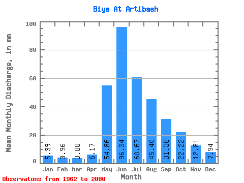
| Mean | 5.38 | 3.99 | 3.88 | 6.17 | 54.86 | 96.34 | 60.66 | 45.39 | 31.38 | 22.22 | 12.81 | 7.94 | 356.03 |
| Standard Deviation | 0.82 | 0.54 | 0.62 | 1.95 | 18.73 | 39.78 | 20.40 | 20.56 | 8.50 | 5.01 | 2.67 | 1.62 | 70.58 |
| Min | 3.65 | 2.46 | 2.27 | 3.31 | 19.72 | 55.58 | 29.58 | 20.92 | 18.31 | 14.79 | 8.90 | 5.54 | 243.57 |
| Max | 7.57 | 5.34 | 5.21 | 10.88 | 97.93 | 219.22 | 122.31 | 109.78 | 51.84 | 38.90 | 20.25 | 13.59 | 517.31 |
| Coefficient of Variation | 0.15 | 0.14 | 0.16 | 0.32 | 0.34 | 0.41 | 0.34 | 0.45 | 0.27 | 0.23 | 0.21 | 0.20 | 0.20 |
| Other Close Sites | ||||||
|---|---|---|---|---|---|---|
| PointID | Latitude | Longitude | Drainage Area | Source | Name | |
| 6668 | "Biya At Kebezen'" | 51.90 | -210419 | SHI | 271.00 | |
 Return to R-Arctic Net Home Page