|
|
|||||||||||||||||
| Point ID: 6668 | Downloads | Plots | Site Data | Other Close Sites | Code: 10042 |
|
|
|||||||||||||||||
| Download | |
|---|---|
| Site Descriptor Information | Site Time Series Data |
| Link to all available data | |
| View: | Time Series | All |
| Units: | m3/s |
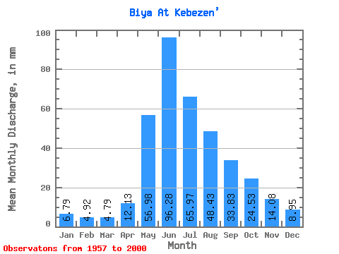
| Statistic | Jan | Feb | Mar | Apr | May | Jun | Jul | Aug | Sep | Oct | Nov | Dec | Annual |
|---|---|---|---|---|---|---|---|---|---|---|---|---|---|
| Mean | 6.79 | 4.96 | 4.79 | 12.13 | 56.97 | 96.28 | 65.96 | 48.43 | 33.83 | 24.53 | 14.09 | 8.95 | 370.99 |
| Standard Deviation | 1.34 | 1.19 | 1.27 | 15.33 | 17.19 | 35.72 | 24.86 | 21.01 | 10.05 | 6.71 | 2.45 | 1.74 | 71.56 |
| Min | 3.72 | 2.36 | 2.70 | 1.51 | 28.18 | 57.64 | 31.63 | 19.89 | 18.14 | 14.54 | 9.95 | 2.91 | 251.67 |
| Max | 9.72 | 7.01 | 10.15 | 102.20 | 107.25 | 206.13 | 165.78 | 113.50 | 56.78 | 45.78 | 20.12 | 13.01 | 561.98 |
| Coefficient of Variation | 0.20 | 0.24 | 0.26 | 1.26 | 0.30 | 0.37 | 0.38 | 0.43 | 0.30 | 0.27 | 0.17 | 0.19 | 0.19 |
| Other Close Sites | ||||||
|---|---|---|---|---|---|---|
| PointID | Latitude | Longitude | Drainage Area | Source | Name | |
| 6929 | "Biya At Artibash" | 51.80 | -200048 | SHI | 299.00 | |
 Return to R-Arctic Net Home Page