|
|
|||||||||||||||||
| Point ID: 2814 | Downloads | Plots | Site Data | Other Close Sites | Code: 05LH005 |
|
|
|||||||||||||||||
| Download | |
|---|---|
| Site Descriptor Information | Site Time Series Data |
| Link to all available data | |
| View: | Time Series | All |
| Units: | mm |
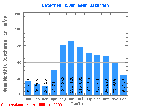
| Statistic | Jan | Feb | Mar | Apr | May | Jun | Jul | Aug | Sep | Oct | Nov | Dec | Annual |
|---|---|---|---|---|---|---|---|---|---|---|---|---|---|
| Mean | 35.23 | 26.61 | 24.02 | 62.21 | 122.86 | 131.13 | 116.89 | 102.91 | 97.31 | 94.27 | 77.69 | 50.18 | 76.21 |
| Standard Deviation | 34.51 | 30.95 | 29.26 | 47.38 | 52.62 | 55.57 | 49.49 | 46.24 | 50.48 | 49.68 | 46.84 | 43.17 | 36.13 |
| Min | 0.04 | 0.00 | 0.00 | 2.35 | 26.60 | 26.10 | 13.70 | 12.80 | 11.20 | 11.20 | 7.62 | 0.55 | 11.11 |
| Max | 168.00 | 139.00 | 127.00 | 233.00 | 295.00 | 317.00 | 277.00 | 234.00 | 286.00 | 291.00 | 273.00 | 249.00 | 201.17 |
| Coefficient of Variation | 0.98 | 1.16 | 1.22 | 0.76 | 0.43 | 0.42 | 0.42 | 0.45 | 0.52 | 0.53 | 0.60 | 0.86 | 0.47 |
| Other Close Sites | ||||||
|---|---|---|---|---|---|---|
| PointID | Latitude | Longitude | Drainage Area | Source | Name | |
| 2812 | "WATERHEN RIVER AT BERNARDIN'S FARM" | 51.81 | 690155 | Hydat | ||
| 2813 | "WATERHEN RIVER AT MCCREERY'S FARM" | 51.83 | 691241 | Hydat | ||
 Return to R-Arctic Net Home Page