|
|
|||||||||||||||||
| Point ID: 2814 | Downloads | Plots | Site Data | Other Close Sites | Code: 05LH005 |
|
|
|||||||||||||||||
| Download | |
|---|---|
| Site Descriptor Information | Site Time Series Data |
| Link to all available data | |
| View: | Time Series | All |
| Units: | m3/s |
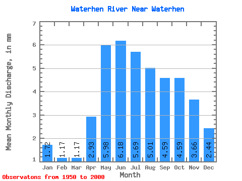
| Statistic | Jan | Feb | Mar | Apr | May | Jun | Jul | Aug | Sep | Oct | Nov | Dec | Annual |
|---|---|---|---|---|---|---|---|---|---|---|---|---|---|
| Mean | 1.71 | 1.18 | 1.17 | 2.93 | 5.98 | 6.18 | 5.69 | 5.01 | 4.59 | 4.59 | 3.66 | 2.44 | 43.73 |
| Standard Deviation | 1.68 | 1.37 | 1.43 | 2.23 | 2.56 | 2.62 | 2.41 | 2.25 | 2.38 | 2.42 | 2.21 | 2.10 | 20.73 |
| Min | 0.00 | 0.00 | 0.00 | 0.11 | 1.29 | 1.23 | 0.67 | 0.62 | 0.53 | 0.55 | 0.36 | 0.03 | 6.38 |
| Max | 8.18 | 6.17 | 6.18 | 10.98 | 14.36 | 14.94 | 13.49 | 11.39 | 13.48 | 14.17 | 12.87 | 12.12 | 115.43 |
| Coefficient of Variation | 0.98 | 1.16 | 1.22 | 0.76 | 0.43 | 0.42 | 0.42 | 0.45 | 0.52 | 0.53 | 0.60 | 0.86 | 0.47 |
| Other Close Sites | ||||||
|---|---|---|---|---|---|---|
| PointID | Latitude | Longitude | Drainage Area | Source | Name | |
| 2812 | "WATERHEN RIVER AT BERNARDIN'S FARM" | 51.81 | 690155 | Hydat | ||
| 2813 | "WATERHEN RIVER AT MCCREERY'S FARM" | 51.83 | 691241 | Hydat | ||
 Return to R-Arctic Net Home Page