|
|
|||||||||||||||||
| Point ID: 2813 | Downloads | Plots | Site Data | Other Close Sites | Code: 05LH004 |
|
|
|||||||||||||||||
| Download | |
|---|---|
| Site Descriptor Information | Site Time Series Data |
| Link to all available data | |
| View: | Time Series | All |
| Units: | mm |
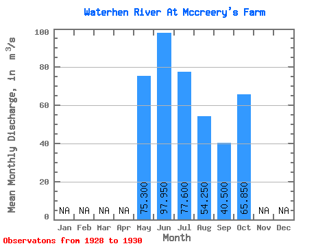
| Statistic | Jan | Feb | Mar | Apr | May | Jun | Jul | Aug | Sep | Oct | Nov | Dec | Annual |
|---|---|---|---|---|---|---|---|---|---|---|---|---|---|
| Mean | 75.30 | 97.95 | 77.60 | 54.25 | 40.50 | 65.85 | |||||||
| Standard Deviation | 7.78 | 24.11 | 19.94 | 9.83 | 0.00 | 40.23 | |||||||
| Min | 69.80 | 80.90 | 63.50 | 47.30 | 40.50 | 37.40 | |||||||
| Max | 80.80 | 115.00 | 91.70 | 61.20 | 40.50 | 94.30 | |||||||
| Coefficient of Variation | 0.10 | 0.25 | 0.26 | 0.18 | 0.00 | 0.61 |
| Other Close Sites | ||||||
|---|---|---|---|---|---|---|
| PointID | Latitude | Longitude | Drainage Area | Source | Name | |
| 2812 | "WATERHEN RIVER AT BERNARDIN'S FARM" | 51.81 | 690155 | Hydat | ||
| 2814 | "WATERHEN RIVER NEAR WATERHEN" | 51.85 | 690176 | Hydat | ||
 Return to R-Arctic Net Home Page