|
|
|||||||||||||||||
| Point ID: 2812 | Downloads | Plots | Site Data | Other Close Sites | Code: 05LH002 |
|
|
|||||||||||||||||
| Download | |
|---|---|
| Site Descriptor Information | Site Time Series Data |
| Link to all available data | |
| View: | Time Series | All |
| Units: | mm |
| Statistic | Jan | Feb | Mar | Apr | May | Jun | Jul | Aug | Sep | Oct | Nov | Dec | Annual |
|---|---|---|---|---|---|---|---|---|---|---|---|---|---|
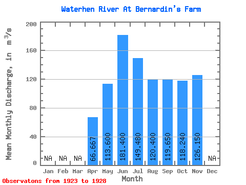
| Mean | 66.67 | 113.60 | 181.40 | 149.48 | 120.40 | 119.65 | 118.24 | 126.15 | |||||
| Standard Deviation | 11.85 | 12.58 | 23.64 | 34.73 | 31.56 | 37.29 | 38.61 | 45.04 | |||||
| Min | 53.30 | 101.00 | 142.00 | 97.40 | 76.00 | 68.40 | 64.90 | 94.30 | |||||
| Max | 75.90 | 128.00 | 204.00 | 182.00 | 151.00 | 156.00 | 154.00 | 158.00 | |||||
| Coefficient of Variation | 0.18 | 0.11 | 0.13 | 0.23 | 0.26 | 0.31 | 0.33 | 0.36 |
| Other Close Sites | ||||||
|---|---|---|---|---|---|---|
| PointID | Latitude | Longitude | Drainage Area | Source | Name | |
| 2813 | "WATERHEN RIVER AT MCCREERY'S FARM" | 51.83 | 691241 | Hydat | ||
| 2814 | "WATERHEN RIVER NEAR WATERHEN" | 51.85 | 690176 | Hydat | ||
 Return to R-Arctic Net Home Page