|
|
|||||||||||||||||
| Point ID: 2775 | Downloads | Plots | Site Data | Other Close Sites | Code: 10CC001 |
|
|
|||||||||||||||||
| Download | |
|---|---|
| Site Descriptor Information | Site Time Series Data |
| Link to all available data | |
| View: | Time Series | All |
| Units: | mm |
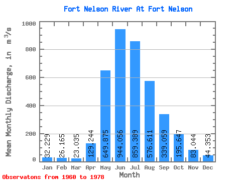
| Statistic | Jan | Feb | Mar | Apr | May | Jun | Jul | Aug | Sep | Oct | Nov | Dec | Annual |
|---|---|---|---|---|---|---|---|---|---|---|---|---|---|
| Mean | 32.23 | 26.16 | 23.04 | 129.24 | 649.88 | 944.06 | 859.39 | 576.61 | 339.06 | 195.65 | 83.04 | 44.35 | 331.91 |
| Standard Deviation | 9.82 | 6.68 | 4.58 | 116.46 | 270.08 | 418.98 | 362.68 | 361.36 | 131.72 | 62.32 | 23.39 | 12.58 | 97.16 |
| Min | 20.90 | 14.30 | 14.90 | 15.90 | 278.00 | 498.00 | 318.00 | 210.00 | 131.00 | 93.70 | 52.40 | 29.70 | 217.17 |
| Max | 55.50 | 38.60 | 31.80 | 340.00 | 1310.00 | 2060.00 | 1530.00 | 1470.00 | 607.00 | 304.00 | 119.00 | 68.40 | 477.13 |
| Coefficient of Variation | 0.30 | 0.26 | 0.20 | 0.90 | 0.42 | 0.44 | 0.42 | 0.63 | 0.39 | 0.32 | 0.28 | 0.28 | 0.29 |
| Other Close Sites | ||||||
|---|---|---|---|---|---|---|
| PointID | Latitude | Longitude | Drainage Area | Source | Name | |
| 2776 | "FORT NELSON RIVER ABOVE MUSKWA RIVER" | 58.67 | 1855223 | Hydat | ||
| 2777 | "MUSKWA RIVER NEAR FORT NELSON" | 58.78 | 1849879 | Hydat | ||
 Return to R-Arctic Net Home Page