|
|
|||||||||||||||||
| Point ID: 2775 | Downloads | Plots | Site Data | Other Close Sites | Code: 10CC001 |
|
|
|||||||||||||||||
| Download | |
|---|---|
| Site Descriptor Information | Site Time Series Data |
| Link to all available data | |
| View: | Time Series | All |
| Units: | m3/s |
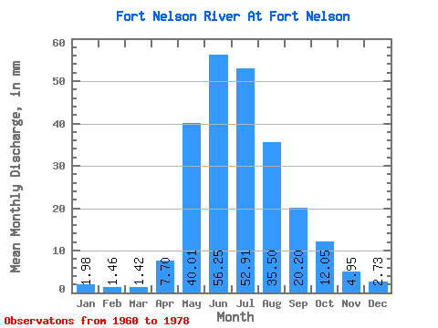
| Statistic | Jan | Feb | Mar | Apr | May | Jun | Jul | Aug | Sep | Oct | Nov | Dec | Annual |
|---|---|---|---|---|---|---|---|---|---|---|---|---|---|
| Mean | 1.98 | 1.47 | 1.42 | 7.70 | 40.01 | 56.25 | 52.91 | 35.50 | 20.20 | 12.04 | 4.95 | 2.73 | 240.81 |
| Standard Deviation | 0.60 | 0.38 | 0.28 | 6.94 | 16.63 | 24.96 | 22.33 | 22.25 | 7.85 | 3.84 | 1.39 | 0.77 | 70.49 |
| Min | 1.29 | 0.80 | 0.92 | 0.95 | 17.11 | 29.67 | 19.58 | 12.93 | 7.81 | 5.77 | 3.12 | 1.83 | 157.56 |
| Max | 3.42 | 2.17 | 1.96 | 20.26 | 80.65 | 122.75 | 94.19 | 90.50 | 36.17 | 18.71 | 7.09 | 4.21 | 346.17 |
| Coefficient of Variation | 0.30 | 0.26 | 0.20 | 0.90 | 0.42 | 0.44 | 0.42 | 0.63 | 0.39 | 0.32 | 0.28 | 0.28 | 0.29 |
| Other Close Sites | ||||||
|---|---|---|---|---|---|---|
| PointID | Latitude | Longitude | Drainage Area | Source | Name | |
| 2776 | "FORT NELSON RIVER ABOVE MUSKWA RIVER" | 58.67 | 1855223 | Hydat | ||
| 2777 | "MUSKWA RIVER NEAR FORT NELSON" | 58.78 | 1849879 | Hydat | ||
 Return to R-Arctic Net Home Page