|
|
|||||||||||||||||
| Point ID: 2777 | Downloads | Plots | Site Data | Other Close Sites | Code: 10CD001 |
|
|
|||||||||||||||||
| Download | |
|---|---|
| Site Descriptor Information | Site Time Series Data |
| Link to all available data | |
| View: | Time Series | All |
| Units: | m3/s |
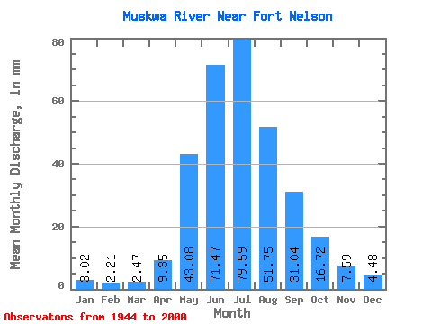
| Statistic | Jan | Feb | Mar | Apr | May | Jun | Jul | Aug | Sep | Oct | Nov | Dec | Annual |
|---|---|---|---|---|---|---|---|---|---|---|---|---|---|
| Mean | 3.02 | 2.23 | 2.47 | 9.35 | 43.08 | 71.47 | 79.58 | 51.74 | 31.04 | 16.72 | 7.59 | 4.48 | 332.18 |
| Standard Deviation | 0.88 | 0.64 | 0.95 | 5.91 | 22.65 | 26.10 | 30.02 | 25.39 | 15.63 | 6.68 | 2.79 | 1.51 | 74.01 |
| Min | 1.44 | 0.93 | 0.77 | 0.80 | 6.38 | 36.90 | 34.30 | 20.58 | 10.51 | 6.78 | 3.22 | 1.78 | 190.69 |
| Max | 5.22 | 4.16 | 6.69 | 28.35 | 115.03 | 167.27 | 150.39 | 133.24 | 86.31 | 34.96 | 14.81 | 8.88 | 498.86 |
| Coefficient of Variation | 0.29 | 0.29 | 0.39 | 0.63 | 0.53 | 0.36 | 0.38 | 0.49 | 0.50 | 0.40 | 0.37 | 0.34 | 0.22 |
| Other Close Sites | ||||||
|---|---|---|---|---|---|---|
| PointID | Latitude | Longitude | Drainage Area | Source | Name | |
| 2775 | "FORT NELSON RIVER AT FORT NELSON" | 58.82 | 1842029 | Hydat | ||
| 2776 | "FORT NELSON RIVER ABOVE MUSKWA RIVER" | 58.67 | 1855223 | Hydat | ||
 Return to R-Arctic Net Home Page