|
|
|||||||||||||||||
| Point ID: 2777 | Downloads | Plots | Site Data | Other Close Sites | Code: 10CD001 |
|
|
|||||||||||||||||
| Download | |
|---|---|
| Site Descriptor Information | Site Time Series Data |
| Link to all available data | |
| View: | Time Series | All |
| Units: | mm |
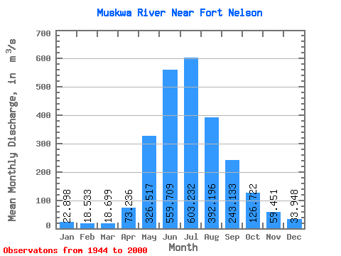
| Statistic | Jan | Feb | Mar | Apr | May | Jun | Jul | Aug | Sep | Oct | Nov | Dec | Annual |
|---|---|---|---|---|---|---|---|---|---|---|---|---|---|
| Mean | 22.90 | 18.53 | 18.70 | 73.24 | 326.52 | 559.71 | 603.23 | 392.20 | 243.13 | 126.72 | 59.45 | 33.95 | 213.66 |
| Standard Deviation | 6.70 | 5.36 | 7.22 | 46.25 | 171.69 | 204.38 | 227.60 | 192.49 | 122.41 | 50.62 | 21.88 | 11.46 | 47.60 |
| Min | 10.90 | 7.74 | 5.86 | 6.23 | 48.40 | 289.00 | 260.00 | 156.00 | 82.30 | 51.40 | 25.20 | 13.50 | 122.66 |
| Max | 39.60 | 34.60 | 50.70 | 222.00 | 872.00 | 1310.00 | 1140.00 | 1010.00 | 676.00 | 265.00 | 116.00 | 67.30 | 320.88 |
| Coefficient of Variation | 0.29 | 0.29 | 0.39 | 0.63 | 0.53 | 0.36 | 0.38 | 0.49 | 0.50 | 0.40 | 0.37 | 0.34 | 0.22 |
| Other Close Sites | ||||||
|---|---|---|---|---|---|---|
| PointID | Latitude | Longitude | Drainage Area | Source | Name | |
| 2775 | "FORT NELSON RIVER AT FORT NELSON" | 58.82 | 1842029 | Hydat | ||
| 2776 | "FORT NELSON RIVER ABOVE MUSKWA RIVER" | 58.67 | 1855223 | Hydat | ||
 Return to R-Arctic Net Home Page