|
|
|||||||||||||||||
| Point ID: 2776 | Downloads | Plots | Site Data | Other Close Sites | Code: 10CC002 |
|
|
|||||||||||||||||
| Download | |
|---|---|
| Site Descriptor Information | Site Time Series Data |
| Link to all available data | |
| View: | Time Series | All |
| Units: | mm |
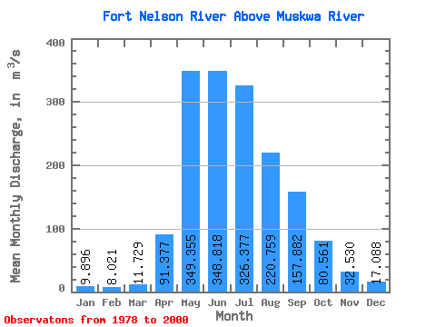
| Statistic | Jan | Feb | Mar | Apr | May | Jun | Jul | Aug | Sep | Oct | Nov | Dec | Annual |
|---|---|---|---|---|---|---|---|---|---|---|---|---|---|
| Mean | 9.90 | 8.02 | 11.73 | 91.38 | 349.36 | 348.82 | 326.38 | 220.76 | 157.88 | 80.56 | 32.53 | 17.09 | 137.90 |
| Standard Deviation | 3.48 | 2.89 | 17.01 | 72.73 | 200.01 | 169.32 | 256.04 | 216.47 | 152.31 | 59.96 | 16.16 | 7.06 | 61.11 |
| Min | 3.71 | 3.63 | 3.44 | 7.79 | 65.20 | 127.00 | 94.30 | 44.30 | 29.00 | 21.30 | 12.40 | 4.61 | 53.43 |
| Max | 18.20 | 16.00 | 86.00 | 271.00 | 716.00 | 689.00 | 1300.00 | 782.00 | 589.00 | 300.00 | 78.40 | 31.60 | 301.09 |
| Coefficient of Variation | 0.35 | 0.36 | 1.45 | 0.80 | 0.57 | 0.48 | 0.78 | 0.98 | 0.96 | 0.74 | 0.50 | 0.41 | 0.44 |
| Other Close Sites | ||||||
|---|---|---|---|---|---|---|
| PointID | Latitude | Longitude | Drainage Area | Source | Name | |
| 2775 | "FORT NELSON RIVER AT FORT NELSON" | 58.82 | 1842029 | Hydat | ||
| 2777 | "MUSKWA RIVER NEAR FORT NELSON" | 58.78 | 1849879 | Hydat | ||
 Return to R-Arctic Net Home Page