|
|
|||||||||||||||||
| Point ID: 6570 | Downloads | Plots | Site Data | Other Close Sites | Code: 9213 |
|
|
|||||||||||||||||
| Download | |
|---|---|
| Site Descriptor Information | Site Time Series Data |
| Link to all available data | |
| View: | Time Series | All |
| Units: | m3/s |
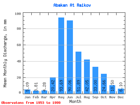
| Statistic | Jan | Feb | Mar | Apr | May | Jun | Jul | Aug | Sep | Oct | Nov | Dec | Annual |
|---|---|---|---|---|---|---|---|---|---|---|---|---|---|
| Mean | 5.09 | 3.84 | 4.28 | 20.42 | 93.68 | 90.06 | 51.88 | 42.05 | 33.00 | 24.66 | 10.50 | 6.10 | 384.34 |
| Standard Deviation | 0.92 | 0.67 | 0.85 | 12.00 | 23.87 | 39.90 | 21.34 | 18.32 | 11.14 | 9.39 | 3.64 | 1.32 | 68.11 |
| Min | 3.38 | 2.33 | 2.95 | 6.11 | 30.46 | 33.95 | 20.36 | 10.78 | 14.66 | 10.95 | 5.75 | 3.88 | 236.32 |
| Max | 7.05 | 5.21 | 6.51 | 71.55 | 172.83 | 202.89 | 106.09 | 94.11 | 60.04 | 59.46 | 21.03 | 9.84 | 536.07 |
| Coefficient of Variation | 0.18 | 0.17 | 0.20 | 0.59 | 0.26 | 0.44 | 0.41 | 0.44 | 0.34 | 0.38 | 0.35 | 0.22 | 0.18 |
| Other Close Sites | ||||||
|---|---|---|---|---|---|---|
| PointID | Latitude | Longitude | Drainage Area | Source | Name | |
| 6540 | "Yenisey At Podsinie" | 53.65 | 108898 | SHI | 2900.00 | |
 Return to R-Arctic Net Home Page