|
|
|||||||||||||||||
| Point ID: 6570 | Downloads | Plots | Site Data | Other Close Sites | Code: 9213 |
|
|
|||||||||||||||||
| Download | |
|---|---|
| Site Descriptor Information | Site Time Series Data |
| Link to all available data | |
| View: | Time Series | All |
| Units: | mm |
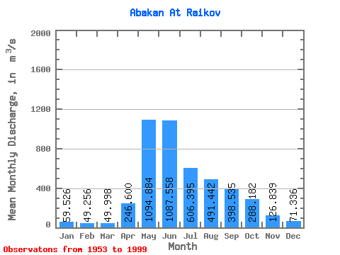
| Statistic | Jan | Feb | Mar | Apr | May | Jun | Jul | Aug | Sep | Oct | Nov | Dec | Annual |
|---|---|---|---|---|---|---|---|---|---|---|---|---|---|
| Mean | 59.53 | 49.26 | 50.00 | 246.60 | 1094.88 | 1087.56 | 606.39 | 491.44 | 398.54 | 288.18 | 126.84 | 71.34 | 381.17 |
| Standard Deviation | 10.74 | 8.64 | 9.90 | 144.94 | 279.04 | 481.82 | 249.36 | 214.07 | 134.57 | 109.76 | 43.93 | 15.41 | 67.55 |
| Min | 39.50 | 29.90 | 34.50 | 73.80 | 356.00 | 410.00 | 238.00 | 126.00 | 177.00 | 128.00 | 69.50 | 45.30 | 234.38 |
| Max | 82.40 | 66.80 | 76.10 | 864.00 | 2020.00 | 2450.00 | 1240.00 | 1100.00 | 725.00 | 695.00 | 254.00 | 115.00 | 531.65 |
| Coefficient of Variation | 0.18 | 0.17 | 0.20 | 0.59 | 0.26 | 0.44 | 0.41 | 0.44 | 0.34 | 0.38 | 0.35 | 0.22 | 0.18 |
| Other Close Sites | ||||||
|---|---|---|---|---|---|---|
| PointID | Latitude | Longitude | Drainage Area | Source | Name | |
| 6540 | "Yenisey At Podsinie" | 53.65 | 108898 | SHI | 2900.00 | |
 Return to R-Arctic Net Home Page