|
|
|||||||||||||||||
| Point ID: 6570 | Downloads | Plots | Site Data | Other Close Sites | Code: 9213 |
|
|
|||||||||||||||||
| Download | |
|---|---|
| Site Descriptor Information | Site Time Series Data |
| Link to all available data | |
|
|
| View: | Statistics | Time Series |
| Units: | m3/s |
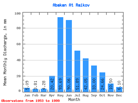
| Statistic | Jan | Feb | Mar | Apr | May | Jun | Jul | Aug | Sep | Oct | Nov | Dec | Annual |
|---|---|---|---|---|---|---|---|---|---|---|---|---|---|
| Mean | 5.09 | 3.84 | 4.28 | 20.42 | 93.68 | 90.06 | 51.88 | 42.05 | 33.00 | 24.66 | 10.50 | 6.10 | 384.34 |
| Standard Deviation | 0.92 | 0.67 | 0.85 | 12.00 | 23.87 | 39.90 | 21.34 | 18.32 | 11.14 | 9.39 | 3.64 | 1.32 | 68.11 |
| Min | 3.38 | 2.33 | 2.95 | 6.11 | 30.46 | 33.95 | 20.36 | 10.78 | 14.66 | 10.95 | 5.75 | 3.88 | 236.32 |
| Max | 7.05 | 5.21 | 6.51 | 71.55 | 172.83 | 202.89 | 106.09 | 94.11 | 60.04 | 59.46 | 21.03 | 9.84 | 536.07 |
| Coefficient of Variation | 0.18 | 0.17 | 0.20 | 0.59 | 0.26 | 0.44 | 0.41 | 0.44 | 0.34 | 0.38 | 0.35 | 0.22 | 0.18 |
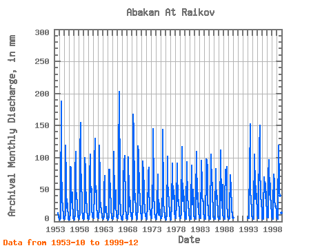
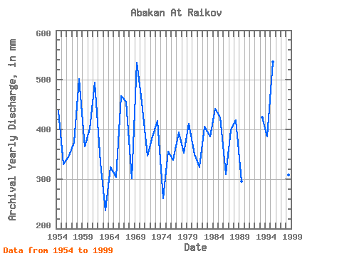
| Year | Jan | Feb | Mar | Apr | May | Jun | Jul | Aug | Sep | Oct | Nov | Dec | Annual | 1953 | 14.12 | 8.36 | 5.83 | 1954 | 4.38 | 3.10 | 3.13 | 6.11 | 30.46 | 187.15 | 87.27 | 39.10 | 38.59 | 19.51 | 13.25 | 5.41 | 437.91 | 1955 | 4.38 | 3.63 | 3.79 | 13.08 | 123.20 | 66.08 | 27.38 | 22.16 | 34.70 | 22.67 | 7.23 | 3.95 | 330.61 | 1956 | 3.41 | 2.56 | 2.97 | 12.92 | 88.13 | 84.47 | 34.74 | 30.03 | 46.13 | 27.98 | 9.94 | 5.19 | 347.45 | 1957 | 4.13 | 3.28 | 3.19 | 11.51 | 78.20 | 109.31 | 54.50 | 37.30 | 31.63 | 24.21 | 10.93 | 6.92 | 374.05 | 1958 | 5.73 | 4.45 | 4.39 | 14.99 | 106.09 | 154.03 | 88.13 | 64.17 | 29.98 | 17.88 | 8.53 | 5.48 | 502.00 | 1959 | 4.06 | 3.52 | 4.00 | 23.27 | 102.67 | 81.16 | 61.95 | 33.97 | 22.36 | 18.22 | 7.39 | 5.31 | 366.00 | 1960 | 4.28 | 3.61 | 3.65 | 14.82 | 70.76 | 105.17 | 66.31 | 47.14 | 51.34 | 20.11 | 7.36 | 8.18 | 401.68 | 1961 | 6.01 | 4.76 | 5.38 | 48.03 | 94.11 | 130.01 | 68.88 | 46.89 | 48.20 | 26.52 | 9.52 | 7.27 | 494.85 | 1962 | 5.73 | 4.39 | 6.19 | 21.53 | 122.35 | 66.00 | 35.68 | 24.47 | 17.39 | 17.03 | 7.79 | 5.81 | 332.46 | 1963 | 4.62 | 3.82 | 4.82 | 6.59 | 54.42 | 71.38 | 22.33 | 15.40 | 23.44 | 14.97 | 9.94 | 4.84 | 236.32 | 1964 | 4.78 | 2.33 | 2.95 | 7.49 | 83.59 | 81.57 | 39.44 | 45.43 | 28.57 | 19.08 | 6.26 | 4.67 | 324.58 | 1965 | 5.09 | 4.08 | 4.21 | 11.59 | 112.94 | 33.95 | 20.36 | 23.10 | 48.78 | 24.21 | 10.02 | 6.85 | 303.51 | 1966 | 5.33 | 4.58 | 4.88 | 15.73 | 104.38 | 202.89 | 56.30 | 36.79 | 16.64 | 10.95 | 5.75 | 3.88 | 468.01 | 1967 | 3.38 | 2.86 | 3.83 | 17.80 | 69.99 | 91.92 | 106.09 | 94.11 | 34.04 | 21.13 | 9.03 | 5.41 | 456.61 | 1968 | 4.71 | 3.05 | 5.21 | 17.14 | 104.38 | 42.98 | 24.21 | 39.53 | 28.24 | 19.93 | 8.28 | 6.20 | 301.86 | 1969 | 4.55 | 3.54 | 3.70 | 24.26 | 172.83 | 139.95 | 49.37 | 35.51 | 39.58 | 44.49 | 13.50 | 6.62 | 535.68 | 1970 | 5.20 | 4.05 | 4.64 | 21.61 | 121.49 | 106.83 | 46.37 | 48.08 | 40.25 | 34.82 | 15.73 | 7.16 | 454.46 | 1971 | 5.54 | 4.22 | 4.36 | 21.28 | 96.68 | 74.70 | 56.21 | 33.20 | 20.95 | 17.20 | 9.61 | 5.37 | 347.58 | 1972 | 5.40 | 3.52 | 3.82 | 25.01 | 67.42 | 75.28 | 87.27 | 40.81 | 36.44 | 23.87 | 11.84 | 6.72 | 385.64 | 1973 | 6.26 | 4.91 | 5.92 | 33.46 | 81.28 | 144.09 | 53.65 | 39.02 | 22.86 | 14.72 | 7.14 | 4.28 | 417.32 | 1974 | 4.29 | 3.07 | 3.34 | 22.44 | 76.49 | 49.44 | 20.36 | 10.78 | 28.24 | 28.49 | 9.77 | 5.57 | 261.45 | 1975 | 5.30 | 4.28 | 4.54 | 10.60 | 64.43 | 143.26 | 42.78 | 26.01 | 21.45 | 22.07 | 7.21 | 3.88 | 355.79 | 1976 | 3.50 | 3.23 | 3.20 | 11.10 | 105.24 | 60.95 | 40.73 | 54.93 | 23.44 | 21.73 | 7.63 | 5.88 | 339.09 | 1977 | 3.56 | 2.78 | 3.52 | 26.25 | 94.11 | 70.14 | 35.68 | 57.07 | 42.07 | 39.36 | 15.57 | 6.59 | 394.87 | 1978 | 6.61 | 5.21 | 5.36 | 29.89 | 94.11 | 82.15 | 32.94 | 37.05 | 31.39 | 15.14 | 8.70 | 4.98 | 352.64 | 1979 | 5.42 | 4.05 | 4.45 | 12.92 | 120.64 | 71.96 | 50.31 | 33.28 | 48.45 | 31.23 | 21.03 | 9.41 | 411.16 | 1980 | 6.20 | 3.84 | 3.96 | 17.14 | 95.83 | 66.66 | 60.32 | 40.73 | 24.26 | 17.54 | 9.77 | 5.93 | 350.08 | 1981 | 4.94 | 3.94 | 4.36 | 27.82 | 90.69 | 41.49 | 27.29 | 33.80 | 50.10 | 25.92 | 8.53 | 7.35 | 324.93 | 1982 | 6.07 | 4.47 | 4.17 | 37.93 | 112.94 | 64.84 | 35.68 | 69.90 | 21.86 | 29.69 | 15.07 | 6.04 | 406.31 | 1983 | 5.93 | 4.57 | 4.94 | 10.10 | 81.28 | 95.23 | 60.32 | 40.04 | 32.21 | 32.43 | 14.08 | 6.00 | 385.57 | 1984 | 5.96 | 3.77 | 3.89 | 8.94 | 74.61 | 96.89 | 99.25 | 84.28 | 25.01 | 25.67 | 9.69 | 6.29 | 441.22 | 1985 | 5.29 | 4.01 | 3.86 | 16.64 | 98.39 | 105.17 | 59.29 | 62.29 | 40.66 | 18.99 | 7.08 | 4.95 | 424.88 | 1986 | 4.60 | 3.41 | 3.64 | 11.01 | 84.88 | 64.10 | 36.02 | 41.33 | 31.80 | 17.45 | 8.27 | 4.91 | 309.92 | 1987 | 3.99 | 3.56 | 3.83 | 12.51 | 115.50 | 91.09 | 44.32 | 21.48 | 28.90 | 59.46 | 9.61 | 7.32 | 399.35 | 1988 | 5.50 | 3.65 | 3.75 | 30.06 | 84.02 | 73.78 | 80.94 | 88.13 | 23.60 | 15.49 | 7.48 | 5.46 | 419.04 | 1989 | 4.94 | 3.56 | 4.64 | 17.64 | 74.78 | 69.81 | 55.44 | 22.67 | 14.66 | 15.49 | 7.31 | 6.31 | 295.83 | 1993 | 6.43 | 4.75 | 5.12 | 21.78 | 80.43 | 152.37 | 52.02 | 33.03 | 31.96 | 23.19 | 8.02 | 5.57 | 424.50 | 1994 | 4.47 | 3.46 | 3.75 | 20.70 | 107.80 | 54.24 | 35.94 | 39.02 | 55.23 | 32.43 | 20.87 | 9.84 | 386.06 | 1995 | 7.05 | 4.62 | 5.55 | 35.20 | 116.36 | 149.89 | 80.25 | 51.08 | 36.69 | 31.23 | 14.24 | 5.41 | 536.07 | 1996 | 4.87 | 3.84 | 4.14 | 19.46 | 72.21 | 55.57 | 62.29 | 36.70 | 60.04 | 34.91 | 12.42 | 7.23 | 372.16 | 1997 | 6.67 | 5.07 | 6.51 | 71.55 | 99.25 | 41.49 | 48.34 | 62.12 | 38.92 | 27.46 | 12.51 | 7.00 | 425.07 | 1998 | 5.14 | 3.53 | 3.99 | 24.43 | 75.55 | 61.12 | 36.53 | 24.30 | 25.09 | 24.81 | 16.64 | 8.10 | 308.18 | 1999 | 5.30 | 4.15 | 4.42 | 13.75 | 123.20 | 62.11 | 47.48 | 41.84 | 23.02 | 41.07 | 13.25 | 7.18 | 383.90 |
|---|
| Other Close Sites | ||||||
|---|---|---|---|---|---|---|
| PointID | Latitude | Longitude | Drainage Area | Source | Name | |
| 6540 | "Yenisey At Podsinie" | 53.65 | 108898 | SHI | 2900.00 | |
 Return to R-Arctic Net Home Page