|
|
|||||||||||||||||
| Point ID: 6540 | Downloads | Plots | Site Data | Other Close Sites | Code: 9030 |
|
|
|||||||||||||||||
| Download | |
|---|---|
| Site Descriptor Information | Site Time Series Data |
| Link to all available data | |
| View: | Time Series | All |
| Units: | m3/s |
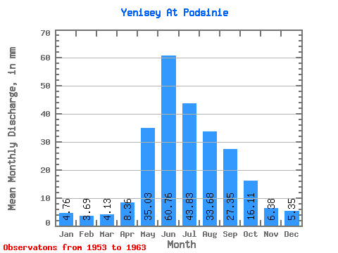
| Statistic | Jan | Feb | Mar | Apr | May | Jun | Jul | Aug | Sep | Oct | Nov | Dec | Annual |
|---|---|---|---|---|---|---|---|---|---|---|---|---|---|
| Mean | 4.76 | 3.72 | 4.13 | 8.36 | 35.02 | 60.76 | 43.82 | 33.67 | 27.35 | 16.11 | 6.38 | 5.35 | 248.92 |
| Standard Deviation | 0.60 | 0.50 | 0.57 | 3.86 | 12.02 | 8.57 | 10.71 | 6.43 | 3.36 | 1.06 | 1.11 | 0.69 | 28.42 |
| Min | 3.81 | 3.10 | 3.24 | 5.78 | 11.28 | 49.14 | 26.92 | 26.78 | 22.00 | 15.20 | 4.52 | 4.23 | 209.82 |
| Max | 5.72 | 4.60 | 5.30 | 19.04 | 49.79 | 70.06 | 58.16 | 44.22 | 31.73 | 18.13 | 8.28 | 6.33 | 299.13 |
| Coefficient of Variation | 0.13 | 0.14 | 0.14 | 0.46 | 0.34 | 0.14 | 0.24 | 0.19 | 0.12 | 0.07 | 0.17 | 0.13 | 0.11 |
| Other Close Sites | ||||||
|---|---|---|---|---|---|---|
| PointID | Latitude | Longitude | Drainage Area | Source | Name | |
| 6570 | "Abakan At Raikov" | 53.58 | 86867 | SHI | 38.00 | |
 Return to R-Arctic Net Home Page