|
|
|||||||||||||||||
| Point ID: 6411 | Downloads | Plots | Site Data | Other Close Sites | Code: 7047 |
|
|
|||||||||||||||||
| Download | |
|---|---|
| Site Descriptor Information | Site Time Series Data |
| Link to all available data | |
| View: | Time Series | All |
| Units: | m3/s |
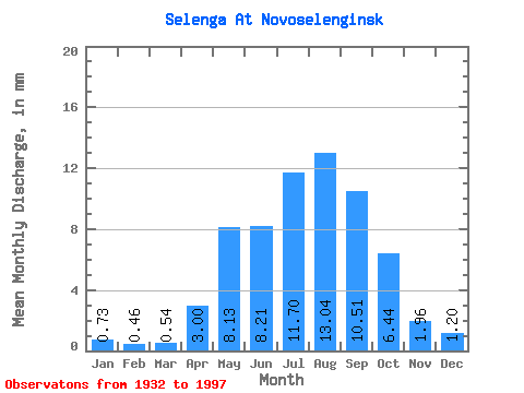
| Statistic | Jan | Feb | Mar | Apr | May | Jun | Jul | Aug | Sep | Oct | Nov | Dec | Annual |
|---|---|---|---|---|---|---|---|---|---|---|---|---|---|
| Mean | 0.73 | 0.46 | 0.54 | 3.00 | 8.13 | 8.21 | 11.70 | 13.04 | 10.51 | 6.43 | 1.96 | 1.20 | 65.46 |
| Standard Deviation | 0.31 | 0.19 | 0.24 | 1.04 | 2.46 | 3.00 | 4.07 | 5.26 | 3.81 | 1.84 | 0.79 | 0.71 | 15.89 |
| Min | 0.19 | 0.13 | 0.16 | 0.65 | 4.00 | 3.35 | 4.73 | 5.55 | 4.95 | 3.38 | 0.79 | 0.46 | 36.97 |
| Max | 2.12 | 1.26 | 1.61 | 6.00 | 16.66 | 18.58 | 25.29 | 29.76 | 21.31 | 12.05 | 5.91 | 5.70 | 109.79 |
| Coefficient of Variation | 0.43 | 0.42 | 0.45 | 0.35 | 0.30 | 0.36 | 0.35 | 0.40 | 0.36 | 0.29 | 0.40 | 0.59 | 0.24 |
| Other Close Sites | ||||||
|---|---|---|---|---|---|---|
| PointID | Latitude | Longitude | Drainage Area | Source | Name | |
| 6420 | "Chikoy At Povorot" | 50.92 | 1219715 | SHI | 22.00 | |
| 6430 | "Khilok At Khailastuy" | 51.20 | 1235358 | SHI | 22.00 | |
 Return to R-Arctic Net Home Page