|
|
|||||||||||||||||
| Point ID: 6411 | Downloads | Plots | Site Data | Other Close Sites | Code: 7047 |
|
|
|||||||||||||||||
| Download | |
|---|---|
| Site Descriptor Information | Site Time Series Data |
| Link to all available data | |
| View: | Time Series | All |
| Units: | mm |
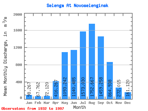
| Statistic | Jan | Feb | Mar | Apr | May | Jun | Jul | Aug | Sep | Oct | Nov | Dec | Annual |
|---|---|---|---|---|---|---|---|---|---|---|---|---|---|
| Mean | 98.27 | 67.76 | 72.12 | 416.27 | 1093.24 | 1140.48 | 1573.03 | 1752.67 | 1459.26 | 864.94 | 272.01 | 161.12 | 746.74 |
| Standard Deviation | 42.10 | 28.66 | 32.12 | 144.95 | 331.28 | 416.01 | 546.48 | 706.80 | 529.02 | 248.03 | 109.64 | 95.47 | 181.22 |
| Min | 25.00 | 19.60 | 21.60 | 89.60 | 537.00 | 465.00 | 636.00 | 746.00 | 687.00 | 454.00 | 110.00 | 61.90 | 421.72 |
| Max | 285.00 | 186.00 | 216.00 | 834.00 | 2240.00 | 2580.00 | 3400.00 | 4000.00 | 2960.00 | 1620.00 | 821.00 | 766.00 | 1252.33 |
| Coefficient of Variation | 0.43 | 0.42 | 0.45 | 0.35 | 0.30 | 0.36 | 0.35 | 0.40 | 0.36 | 0.29 | 0.40 | 0.59 | 0.24 |
| Other Close Sites | ||||||
|---|---|---|---|---|---|---|
| PointID | Latitude | Longitude | Drainage Area | Source | Name | |
| 6420 | "Chikoy At Povorot" | 50.92 | 1219715 | SHI | 22.00 | |
| 6430 | "Khilok At Khailastuy" | 51.20 | 1235358 | SHI | 22.00 | |
 Return to R-Arctic Net Home Page