|
|
|||||||||||||||||
| Point ID: 6420 | Downloads | Plots | Site Data | Other Close Sites | Code: 7076 |
|
|
|||||||||||||||||
| Download | |
|---|---|
| Site Descriptor Information | Site Time Series Data |
| Link to all available data | |
| View: | Time Series | All |
| Units: | mm |
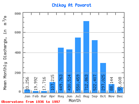
| Statistic | Jan | Feb | Mar | Apr | May | Jun | Jul | Aug | Sep | Oct | Nov | Dec | Annual |
|---|---|---|---|---|---|---|---|---|---|---|---|---|---|
| Mean | 33.26 | 19.99 | 17.72 | 107.22 | 449.76 | 430.51 | 550.46 | 712.86 | 522.41 | 297.02 | 88.14 | 55.61 | 273.75 |
| Standard Deviation | 14.27 | 9.81 | 9.36 | 58.32 | 160.33 | 257.20 | 258.91 | 976.53 | 222.10 | 92.60 | 32.97 | 19.03 | 115.25 |
| Min | 11.10 | 4.28 | 2.45 | 17.20 | 183.00 | 27.30 | 85.10 | 78.90 | 119.00 | 99.50 | 21.80 | 10.20 | 92.40 |
| Max | 78.90 | 51.30 | 53.40 | 270.00 | 805.00 | 1710.00 | 1170.00 | 7719.00 | 1270.00 | 569.00 | 194.00 | 102.00 | 912.02 |
| Coefficient of Variation | 0.43 | 0.49 | 0.53 | 0.54 | 0.36 | 0.60 | 0.47 | 1.37 | 0.42 | 0.31 | 0.37 | 0.34 | 0.42 |
| Other Close Sites | ||||||
|---|---|---|---|---|---|---|
| PointID | Latitude | Longitude | Drainage Area | Source | Name | |
| 6411 | "Selenga At Novoselenginsk" | 51.10 | 1217153 | SHI | 273.00 | |
| 6430 | "Khilok At Khailastuy" | 51.20 | 1235358 | SHI | 22.00 | |
 Return to R-Arctic Net Home Page