|
|
|||||||||||||||||
| Point ID: 6420 | Downloads | Plots | Site Data | Other Close Sites | Code: 7076 |
|
|
|||||||||||||||||
| Download | |
|---|---|
| Site Descriptor Information | Site Time Series Data |
| Link to all available data | |
| View: | Time Series | All |
| Units: | m3/s |
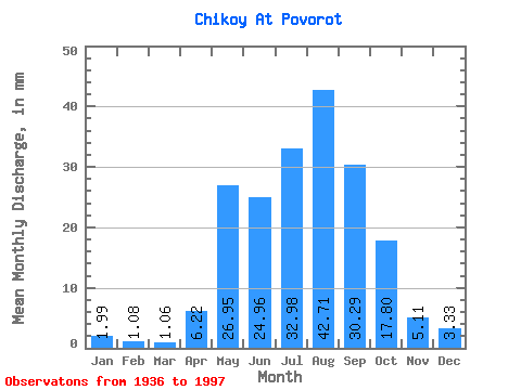
| Statistic | Jan | Feb | Mar | Apr | May | Jun | Jul | Aug | Sep | Oct | Nov | Dec | Annual |
|---|---|---|---|---|---|---|---|---|---|---|---|---|---|
| Mean | 1.99 | 1.09 | 1.06 | 6.22 | 26.95 | 24.96 | 32.98 | 42.71 | 30.29 | 17.80 | 5.11 | 3.33 | 193.28 |
| Standard Deviation | 0.85 | 0.54 | 0.56 | 3.38 | 9.61 | 14.91 | 15.51 | 58.50 | 12.88 | 5.55 | 1.91 | 1.14 | 81.37 |
| Min | 0.67 | 0.23 | 0.15 | 1.00 | 10.96 | 1.58 | 5.10 | 4.73 | 6.90 | 5.96 | 1.26 | 0.61 | 65.24 |
| Max | 4.73 | 2.80 | 3.20 | 15.66 | 48.23 | 99.16 | 70.09 | 462.45 | 73.64 | 34.09 | 11.25 | 6.11 | 643.93 |
| Coefficient of Variation | 0.43 | 0.49 | 0.53 | 0.54 | 0.36 | 0.60 | 0.47 | 1.37 | 0.42 | 0.31 | 0.37 | 0.34 | 0.42 |
| Other Close Sites | ||||||
|---|---|---|---|---|---|---|
| PointID | Latitude | Longitude | Drainage Area | Source | Name | |
| 6411 | "Selenga At Novoselenginsk" | 51.10 | 1217153 | SHI | 273.00 | |
| 6430 | "Khilok At Khailastuy" | 51.20 | 1235358 | SHI | 22.00 | |
 Return to R-Arctic Net Home Page