|
|
|||||||||||||||||
| Point ID: 6430 | Downloads | Plots | Site Data | Other Close Sites | Code: 7102 |
|
|
|||||||||||||||||
| Download | |
|---|---|
| Site Descriptor Information | Site Time Series Data |
| Link to all available data | |
| View: | Time Series | All |
| Units: | m3/s |
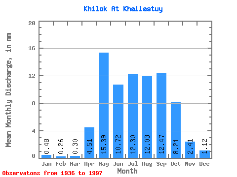
| Statistic | Jan | Feb | Mar | Apr | May | Jun | Jul | Aug | Sep | Oct | Nov | Dec | Annual |
|---|---|---|---|---|---|---|---|---|---|---|---|---|---|
| Mean | 0.48 | 0.26 | 0.30 | 4.51 | 15.39 | 10.72 | 12.30 | 12.03 | 12.47 | 8.21 | 2.41 | 1.12 | 80.43 |
| Standard Deviation | 0.33 | 0.17 | 0.19 | 3.19 | 7.69 | 6.42 | 7.90 | 6.46 | 8.04 | 4.06 | 1.15 | 0.70 | 29.65 |
| Min | 0.01 | 0.00 | 0.00 | 0.61 | 5.66 | 2.98 | 3.27 | 2.91 | 2.55 | 2.70 | 0.85 | 0.23 | 34.35 |
| Max | 1.44 | 0.69 | 0.85 | 16.51 | 38.88 | 38.03 | 40.27 | 27.97 | 42.37 | 20.21 | 6.19 | 3.45 | 144.59 |
| Coefficient of Variation | 0.68 | 0.65 | 0.62 | 0.71 | 0.50 | 0.60 | 0.64 | 0.54 | 0.65 | 0.49 | 0.48 | 0.62 | 0.37 |
| Other Close Sites | ||||||
|---|---|---|---|---|---|---|
| PointID | Latitude | Longitude | Drainage Area | Source | Name | |
| 6411 | "Selenga At Novoselenginsk" | 51.10 | 1217153 | SHI | 273.00 | |
| 6420 | "Chikoy At Povorot" | 50.92 | 1219715 | SHI | 22.00 | |
 Return to R-Arctic Net Home Page