|
|
|||||||||||||||||
| Point ID: 3619 | Downloads | Plots | Site Data | Other Close Sites | Code: 10GB001 |
|
|
|||||||||||||||||
| Download | |
|---|---|
| Site Descriptor Information | Site Time Series Data |
| Link to all available data | |
| View: | Time Series | All |
| Units: | m3/s |
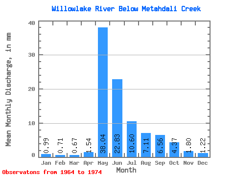
| Statistic | Jan | Feb | Mar | Apr | May | Jun | Jul | Aug | Sep | Oct | Nov | Dec | Annual |
|---|---|---|---|---|---|---|---|---|---|---|---|---|---|
| Mean | 0.99 | 0.72 | 0.67 | 1.54 | 38.04 | 22.83 | 10.60 | 7.11 | 6.56 | 4.37 | 1.80 | 1.22 | 95.85 |
| Standard Deviation | 0.50 | 0.31 | 0.25 | 2.43 | 16.24 | 5.96 | 5.61 | 5.12 | 4.84 | 3.11 | 0.95 | 0.59 | 17.93 |
| Min | 0.40 | 0.37 | 0.30 | 0.30 | 14.50 | 12.43 | 4.77 | 2.59 | 2.38 | 1.87 | 0.55 | 0.61 | 63.54 |
| Max | 1.95 | 1.43 | 1.21 | 8.75 | 66.62 | 33.25 | 26.00 | 21.42 | 17.45 | 12.64 | 3.86 | 2.52 | 131.28 |
| Coefficient of Variation | 0.50 | 0.44 | 0.38 | 1.57 | 0.43 | 0.26 | 0.53 | 0.72 | 0.74 | 0.71 | 0.53 | 0.49 | 0.19 |
| Other Close Sites | ||||||
|---|---|---|---|---|---|---|
| PointID | Latitude | Longitude | Drainage Area | Source | Name | |
| 3621 | "WILLOWLAKE RIVER ABOVE METAHDALI CREEK" | 62.65 | 1635870 | Hydat | ||
 Return to R-Arctic Net Home Page