|
|
| Point ID: 3619 | Downloads | Plots | Site Data | Other Close Sites | Code: 10GB001 |
|
| Download | |
|---|---|
| Site Descriptor Information | Site Time Series Data |
| Link to all available data | |
|
|
|
| View: | Statistics | All |
| Units: | m3/s |
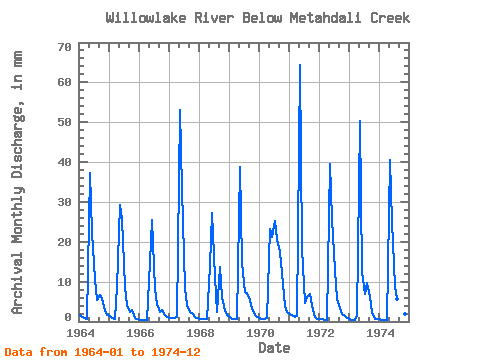
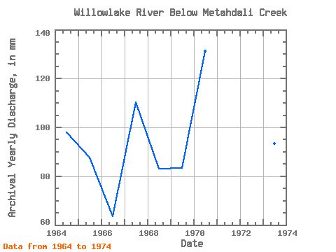
| Year | Jan | Feb | Mar | Apr | May | Jun | Jul | Aug | Sep | Oct | Nov | Dec | Annual | 1964 | 1.75 | 1.04 | 0.89 | 0.69 | 38.41 | 22.25 | 11.04 | 5.70 | 6.64 | 5.97 | 2.64 | 1.76 | 98.17 | 1965 | 1.37 | 0.93 | 0.66 | 8.75 | 30.31 | 25.79 | 9.05 | 4.23 | 2.40 | 3.00 | 0.98 | 0.61 | 87.83 | 1966 | 0.40 | 0.37 | 0.30 | 0.30 | 15.41 | 25.41 | 8.40 | 4.58 | 2.45 | 3.07 | 1.69 | 1.27 | 63.54 | 1967 | 0.94 | 0.74 | 0.92 | 1.06 | 54.74 | 33.25 | 8.58 | 4.29 | 2.38 | 2.14 | 1.23 | 0.92 | 110.49 | 1968 | 0.68 | 0.62 | 0.67 | 0.59 | 14.50 | 27.31 | 11.55 | 2.59 | 13.65 | 6.40 | 2.74 | 1.80 | 83.12 | 1969 | 1.09 | 0.67 | 0.64 | 0.74 | 39.97 | 14.79 | 7.63 | 7.30 | 5.42 | 3.37 | 1.53 | 1.08 | 83.53 | 1970 | 0.89 | 0.69 | 0.68 | 0.86 | 23.91 | 21.24 | 26.00 | 21.42 | 17.45 | 12.64 | 3.86 | 2.52 | 131.28 | 1971 | 1.95 | 1.43 | 1.21 | 1.28 | 66.62 | 18.08 | 4.77 | 6.35 | 6.95 | 3.92 | 1.20 | 0.67 | 113.41 | 1972 | 0.59 | 0.51 | 0.50 | 0.46 | 40.89 | 25.67 | 13.32 | 5.79 | 3.38 | 1.87 | 1.42 | 0.97 | 94.71 | 1973 | 0.66 | 0.45 | 0.51 | 1.75 | 51.86 | 12.43 | 7.05 | 10.02 | 6.14 | 2.25 | 0.55 | 0.63 | 93.34 | 1974 | 0.62 | 0.44 | 0.44 | 0.47 | 41.80 | 24.91 | 9.24 | 5.89 | 5.25 | 3.42 | 1.94 | 1.13 | 94.94 |
|---|
| Other Close Sites | ||||||
|---|---|---|---|---|---|---|
| PointID | Latitude | Longitude | Drainage Area | Source | Name | |
| 3621 | "WILLOWLAKE RIVER ABOVE METAHDALI CREEK" | 62.65 | 1635870 | Hydat | ||
 Return to R-Arctic Net Home Page