|
|
|||||||||||||||||
| Point ID: 3621 | Downloads | Plots | Site Data | Other Close Sites | Code: 10GB006 |
|
|
|||||||||||||||||
| Download | |
|---|---|
| Site Descriptor Information | Site Time Series Data |
| Link to all available data | |
| View: | Time Series | All |
| Units: | m3/s |
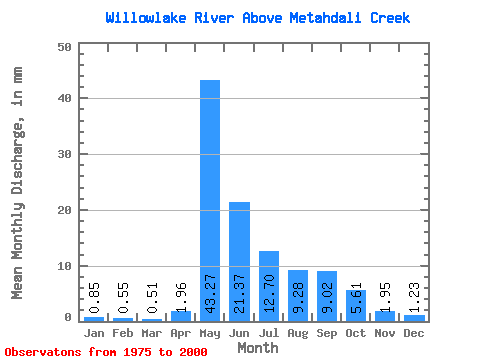
| Statistic | Jan | Feb | Mar | Apr | May | Jun | Jul | Aug | Sep | Oct | Nov | Dec | Annual |
|---|---|---|---|---|---|---|---|---|---|---|---|---|---|
| Mean | 0.85 | 0.56 | 0.51 | 1.96 | 43.26 | 21.37 | 12.70 | 9.28 | 9.02 | 5.61 | 1.95 | 1.23 | 103.39 |
| Standard Deviation | 0.44 | 0.29 | 0.26 | 2.02 | 18.03 | 10.93 | 10.47 | 7.69 | 8.59 | 4.50 | 1.55 | 0.81 | 40.94 |
| Min | 0.26 | 0.25 | 0.19 | 0.24 | 20.02 | 4.05 | 0.82 | 0.53 | 0.53 | 0.59 | 0.19 | 0.14 | 37.34 |
| Max | 1.83 | 1.33 | 1.35 | 8.42 | 86.70 | 40.55 | 50.51 | 35.80 | 34.26 | 15.11 | 6.09 | 2.81 | 169.45 |
| Coefficient of Variation | 0.52 | 0.51 | 0.52 | 1.03 | 0.42 | 0.51 | 0.82 | 0.83 | 0.95 | 0.80 | 0.80 | 0.66 | 0.40 |
| Other Close Sites | ||||||
|---|---|---|---|---|---|---|
| PointID | Latitude | Longitude | Drainage Area | Source | Name | |
| 3619 | "WILLOWLAKE RIVER BELOW METAHDALI CREEK" | 62.65 | 1636312 | Hydat | ||
 Return to R-Arctic Net Home Page