|
|
|||||||||||||||||
| Point ID: 3621 | Downloads | Plots | Site Data | Other Close Sites | Code: 10GB006 |
|
|
|||||||||||||||||
| Download | |
|---|---|
| Site Descriptor Information | Site Time Series Data |
| Link to all available data | |
| View: | Time Series | All |
| Units: | mm |
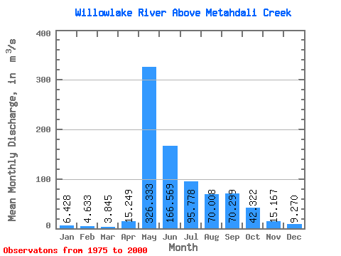
| Statistic | Jan | Feb | Mar | Apr | May | Jun | Jul | Aug | Sep | Oct | Nov | Dec | Annual |
|---|---|---|---|---|---|---|---|---|---|---|---|---|---|
| Mean | 6.43 | 4.63 | 3.84 | 15.25 | 326.33 | 166.57 | 95.78 | 70.01 | 70.30 | 42.32 | 15.17 | 9.27 | 66.18 |
| Standard Deviation | 3.34 | 2.37 | 1.99 | 15.76 | 135.97 | 85.18 | 78.95 | 58.02 | 66.95 | 33.95 | 12.07 | 6.13 | 26.21 |
| Min | 1.99 | 2.05 | 1.43 | 1.91 | 151.00 | 31.60 | 6.22 | 3.98 | 4.09 | 4.46 | 1.51 | 1.08 | 23.90 |
| Max | 13.80 | 11.00 | 10.20 | 65.60 | 654.00 | 316.00 | 381.00 | 270.00 | 267.00 | 114.00 | 47.50 | 21.20 | 108.46 |
| Coefficient of Variation | 0.52 | 0.51 | 0.52 | 1.03 | 0.42 | 0.51 | 0.82 | 0.83 | 0.95 | 0.80 | 0.80 | 0.66 | 0.40 |
| Other Close Sites | ||||||
|---|---|---|---|---|---|---|
| PointID | Latitude | Longitude | Drainage Area | Source | Name | |
| 3619 | "WILLOWLAKE RIVER BELOW METAHDALI CREEK" | 62.65 | 1636312 | Hydat | ||
 Return to R-Arctic Net Home Page